(To protect my work from plagiarism, I have decided not to disclose my sources. Check profile for info)
A small town called Bilhari, located in the Katni District of present day Madhya Pradesh, once had an impregnable fort. The town is supposed to be very ancient since during the British rule explorers described the place as having numerous ruins of ancient temples and step-wells. In the past, the town was supposedly called Babaot Nagri or Babaotee, and then Papaot. The inhabitants of the place were of the belief that the name Bilhari was derived from a kind of Pan (Betel Leaf) that grew in abundance in the area. In 1873-74, fifteen years after the destruction of the Fort, A. Cunningham, who was the Director General of Archaeological Survey of India, toured the area and gave an account of the ruins of Bilhari. By then the British referred to the place as Bilhari. According to Cunningham, Bilhari was founded by Raja Karn Dahariya at the time of Bhartri or Bhartrihari, the brother of Vikramaditya. It was called Puphavati or Pushpavati (the town of flowers). This name lasted until tenth century of Samvat and was superseded by Bilhari.
The fort that was located in Bilhari was built of red sandstone quarried from the spurs of the Kaimore Range which bordered the same district. It was built by Luchmann Singh Pudhae Chutree in AD 1489 and destroyed by Capt D. C. Vanrenen in August 1857. The order to destroy was given by Major Erskine, Commissioner, Saugor Division. Records of 1874 show the name as of the ruler as Lakshman Sinh Parihar who lived in the tenth century.
According to sources, several centuries ago the town had a circumference of 24 miles, which suggests that it was an important flourishing town of the region. The centre of the town had a building, which was in all probability a town hall. From this building, in middle of the eighteenth century, the Deputy Commissioner of Jabalpur removed a stone etched with the names of thirty seven rulers of the area. The last one mentioned in the list was crowned as ruler in 1758 AD. It is also believed that Aurangzeb had visited this city during his reign and was responsible for getting many of the temples demolished and statues disfigured.
During the First War of Independence of 1857, the Bilheri (Bilhari) Fort was occupied by a group of rebels under Raghunath Singh Bundela of Panna. As soon as the British authorities became aware of this, they sent troops from Jabalpur and Nagod to attack the place. However, the rebels had decamped before the troops arrived. Nevertheless, the British decided to destroy the Fort.
This Fort was situated ‘56 miles N. N. West of Jubbulpore.’ However, the location of the village is to the north east of Jabalpur, just about 15 km west of Katni (called Murwara Katni).
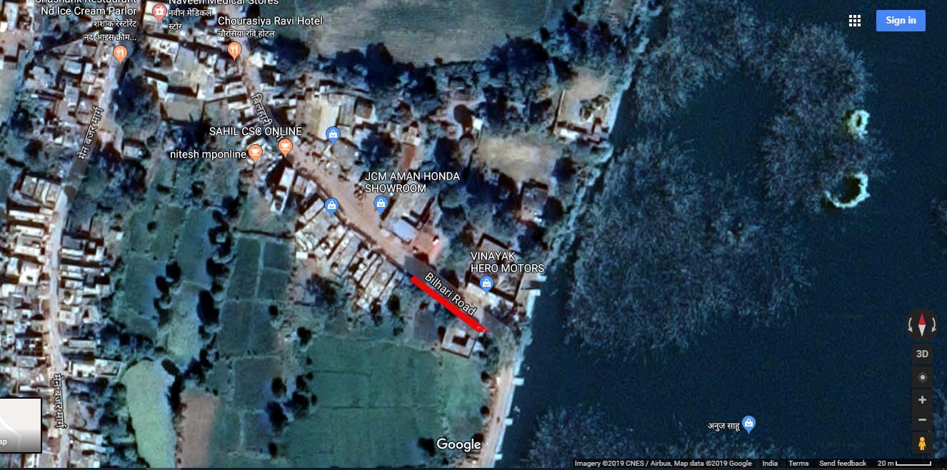
Source: Google Maps – Screen shot taken on 3 March, 2019. The name of the town is Bilhari and the location of the tank on the east of a set of old structure suggests that this was the location of Bilhari fort. Some fairly recent social media posts show the an old temple in the said location which corresponds with the layout map of the fort given ahead in the article.
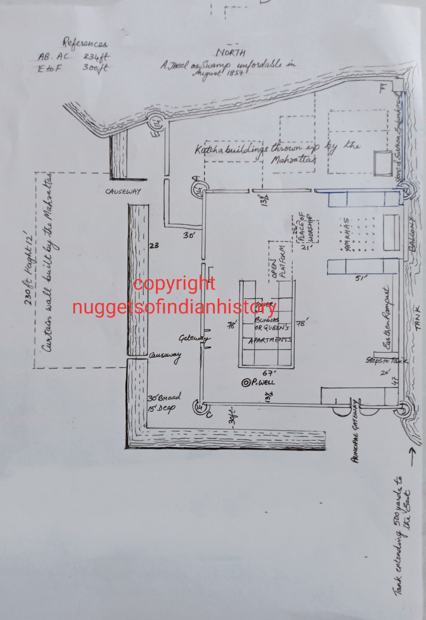
The description of the Fort by its destroyer Captain Vanrenen is critical for our understanding of its condition and situation before it was consigned to gun fire. Vanrenen wrote that the fort was square in shape with a side of 234 feet. At the corners stood circular towers of diameter of 14 feet. The principal gateway had “octangular bastions, one on each side.” The north wall of the Fort was irregular and was in line with an “impassable swamp.” The ends of the wall had towers. To the east, there was an unfordable tank. The only clear space to reach the Fort was in front of the principal gateway, which was located in the south. The south and west were protected by deep ditches that were 12 feet deep and 30 feet wide.
The walls of the square redoubt, were about 40 feet high, and 4 ½ feet thick, the bastions being 10 feet higher, and the whole was carefully loopholed for musketry fire. The fire through these loopholes was obtained from the roof of a line of buildings, or verandah, open at the rear. This banquet was of great solidity, being supported on cut stone pillars. Single stone slabs spanned these pillars, which were faced with line cement.
The northern wall, which faced the swamp/jheel, was 25 feet high and 3 feet thick. Just behind this wall was another wall that was 5 feet thick and higher than the first wall. The difference in height was sufficient enough to send musketry fire over the first wall. The “curtain wall,” which connected this second wall to the square redoubt, was 18 feet high and 5 feet thick. The material used for these walls was stone and lime cement. Capt Vanrenen writes that ‘all the works were of immense strength… and were found [by him] to be in excellent preservation.’
He goes on to describe the interiors:
The open colonnade, with a few interior apartments, would have afforded ample cover for a large body of men, with space for their supplies. Water was obtained from the pucka well within the works, with an additional supply from the eastern tank, by means of a flight of stone steps leading down to it.
Bilheree Fort boasted of an Aamkhass, or Audience Hall, which with some interior apartments, occupied a space of 78 feet by 51 feet. This was a fine hall of elegantly shaped stone pillars, supporting a roof also of stone slabs and lime cement.
Situated in nearly the centre of the redoubt was the Ranee’s or Queen’s apartment, a two- storied building 78 feet by 68 feet. This and the Aamkhass were of the most solid construction.
A place of worship was provided (contained within a rectangular enclosure) in front of the Aamkhass.
The Captain believed then that the walls and fortifications would have held on for a considerable period of time against attack and they would have even “resisted the action of field guns.” According to him, “without guns of come calibre the place was unassailable from the north and east, and (unless the attacking party first occupied the town of Bilheree, which is within range of musketry fire) it was unassailable from the west.” Nevertheless, in order to make the Fort “untenable, and uninhabitable,” Captain Vanrenen managed to completely destroy the walls on the south and south western parts.
Source: Withheld. The map is copied from a black and white facsimile of the original printed in a nineteenth century periodical.
According to papers recovered by the British from the Kanungo Mundlah Ram, Lakshman Singh held a jagir from the Nagode Raja which consisted of three hundred villages and which went on to form the Pargana of Bilheri. Lakshman Singh and his descendents possessed the jagir for seventy years, that is until 1559. In 1559, the jagir was taken by “strategem” by Gond Raja Mugru Duj who had married the grand-daughter of Lakshman Singh. The Gonds under the Mundlah chiefs retained the jagir for 115 years. Failure to pay taxes levied by the Mundlah Raja, the jagir was taken away and given to Jaswant Rao Maratha in 1674. Jaswant Rao held the government under the Mundlah Raja. On his death, Jaswant Rao’s son, Munga Rao took charge and reigned for 78 years. In 1742, when the Mundlah Raja was at war with the Raja of Nagpur, Mundlah Raja suspecting Munga Rao of treachery got him killed and transferred the jagir to his favourites Nawab Ajeet Khan and Ahmad Khan. On the deaths of these latter two in 1767, the jagir of the place lapsed to the Mundlah Raja who managed it on his own and derived yearly revenue of 20,000 rupees. In 1779, the Sagar Raja Balwant Rao Pundit defeated and ousted the Mundlah Raja and he soon lost the place to Raghoji of Nagpur. In 1816, the British took control of the area.
Addendum
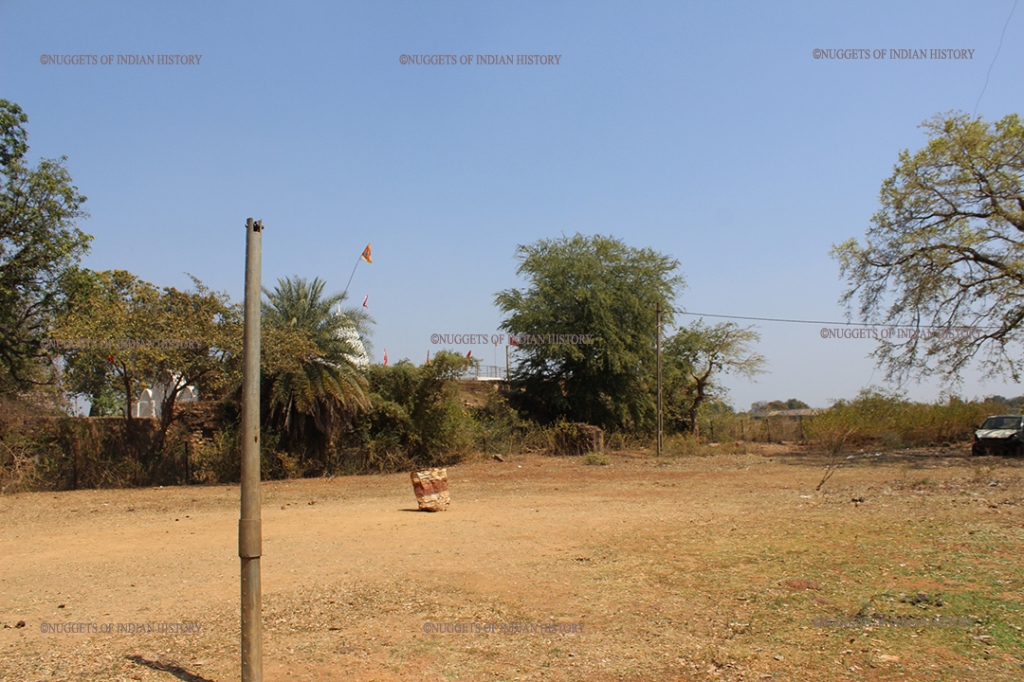
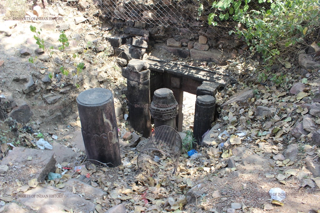
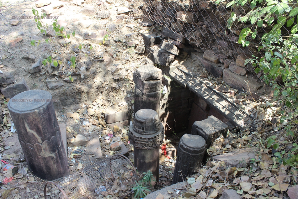
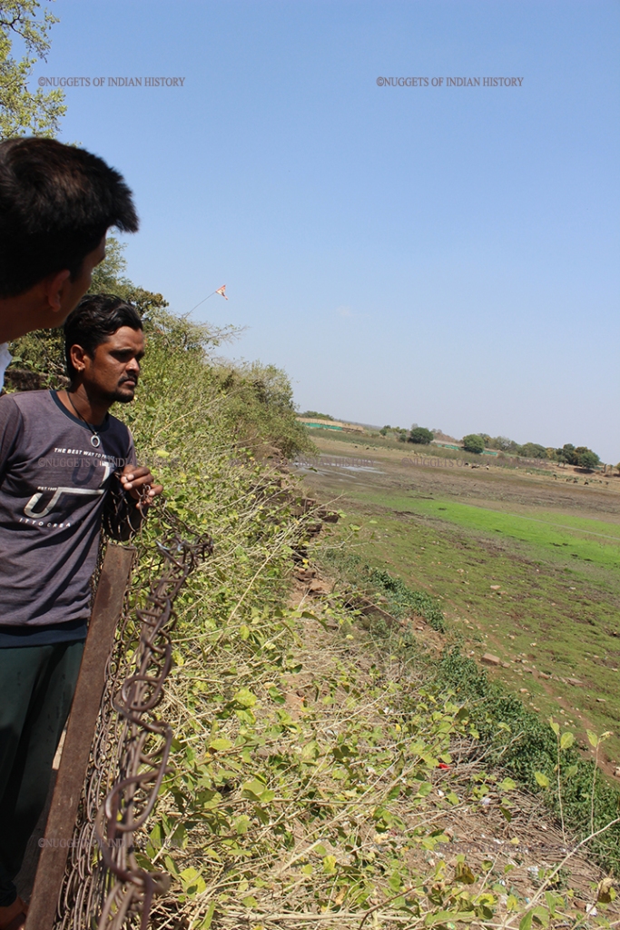
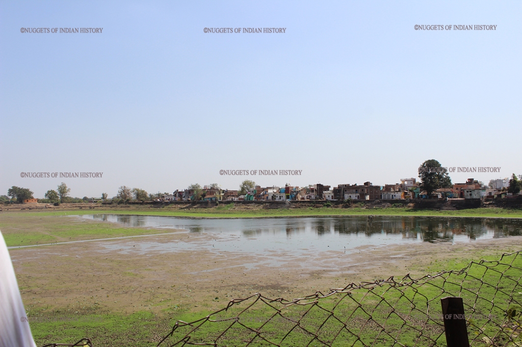
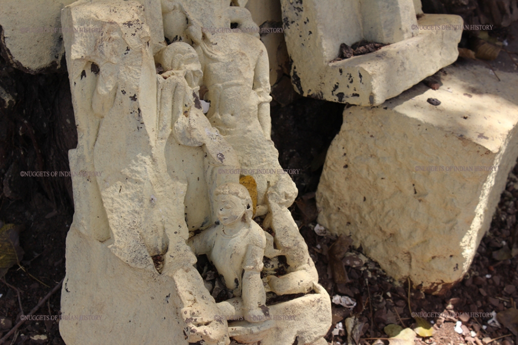
I visited Bilhari in early 2022. Took photographs of the remains of the fort. The remnants of the old fort are very few. There are no surrounding walls left except for a small section with some steps leading up. No moat exists but where it would have been, if we check with the map posted above and with Google maps, a road has come up over the moat on the south side of the site. Part of the Queen’s apartments still stands. Its a two storied building with steps leading up to the first and second floor. There is passage going to some basement. It was too dark inside so didnt venture in. Adjacent to this, with some gap, is a building which houses the Bilhari Police Station. No sign of the main gateway of the fort, but the present day business of Vinayak Hero Motors sits right where gateway would have been. The lake is nearly dry. However, steps from the inside of the fort leading to the lake are still intact but in a dilapidated condition with garbage thrown all around. These steps are marked in the layout of the fort given above. Beautiful columns still stand though some are broken/damaged due to neglect. Here and there lie stone statues and sculptures, some painted with cream coloured paint which hide whatever intricate carvings these pieces have on them. Unfortunately, the government body responsible for maintenance of such ruins have placed a board giving incorrect information of the remnants. They believe the ruins are of a “math” (a monastery) and therefore the description, whatever little is mentioned, is rather incorrect.
Interestingly, there is an inscription on one of the pillars of the Queens’ apartments. Picture is attached. The government board mentions what is inscribed. However, what caught my eye was the three-fish symbol with a common head right below the inscription.