James Prinsep’s Survey of Benares (Varanasi or Kashi)

James Prinsep arrived in India in the second decade of the nineteenth century. His knowledge of chemistry resulted in his appointment as an assay master at the mint in Benares, now Varanasi, by the East India Company in 1820, though he “never belonged either to the civil or military service”[1] of the East India Company. He lived in Varanasi for ten years until the mint was abolished and he was asked to take the same position at the Calcutta (now Kolkata) mint.

In his free time, Prinsep became absorbed in studying Indian culture and history. His empirical study of Benares as a city and of its people presents a very interesting first-hand information about Benares of the 1820s. He not only recorded in writing what he saw but also drew maps, illustrations of people and conducted population census of the city. His rudimentary knowledge of the Sanskrit language did not deter him from seeking and exploring inscriptions and manuscripts found in Benares.

Many articles have been written on Prinsep and his contributions to Indology. This short article is about the map of Benares created by Prinsep.[2]

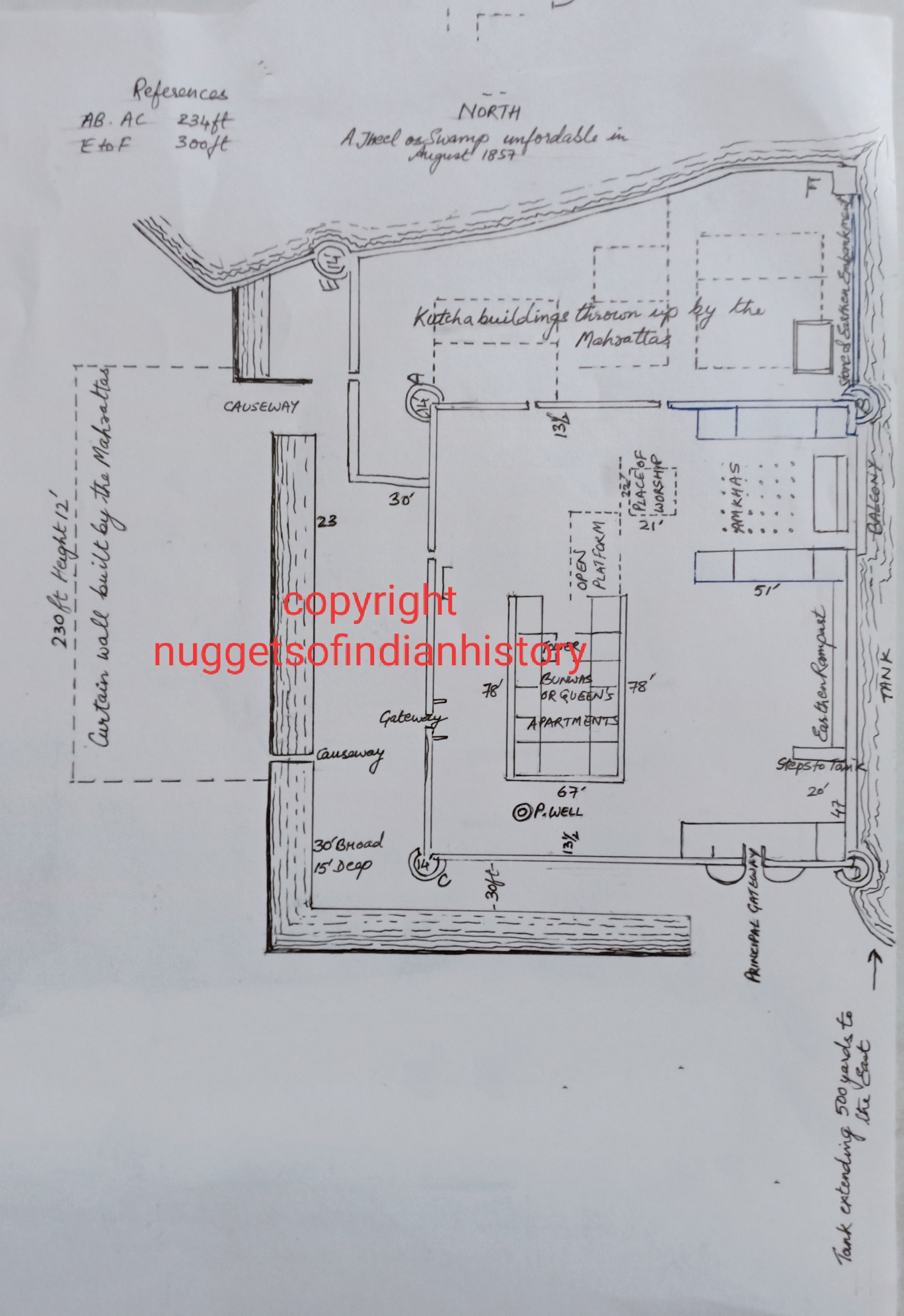
It is a very detailed map which is in the Asiatic Library, Kolkata.

He writes a Memoranda on the map which states the following:

Bunarus (in Sanscrit Baranusee) so called from its Site between the Burna & Ussee or from Raja Bunar, in whose time the present town was founded after the Moosulman invasions 800 Years ago; contains about 600,000 inhabitants 3/4ths Hindoos & 1/4th Moosulmans, chiefly Weavers. The Streets are from 1 to 3 yards wide, mostly terminating in narrow Doors.

Prinsep listed 91 “Hindoo” temples of Benares. He calls them “Shiwalas.”

S. NoAs mentioned on the original mapS. No.As mentioned on the original map
1Gyna bapee47Ugneswur
2Visheshwur48Oopusanteswur
3Unn pŏŏrna49Byunkutesh
4Shunyshchureswur50Gubhusteeswur
5Adivishweshwur51Bind madho
6Dhoondhiraj52Dŏŏgdh binayuk
7Sakshee binayuk53Umriteswur
8Koteeswur54Kâl Bhyro
9Bruhmeswur55Sheetla debee
10Ugusteswur56Duňd panee
11Lukshmi debee57Papbhukshewur
12Tilbhandeswur58Mudhmeswur
13Reňooka debee59Rutneswur
14Dŏŏrga60Rajrajeswuree
15Dŏŏrg binayuk61Mankeswur
16Kŏŏkkŏŏteswur62Krittibaseswur
17Koorŏŏkshetr63Brid     wur (Incomplete name as map damaged)
18Pŏŏshkur64Ulpumrityoohueswur
19Jugunnath65Jageswur
20Lolark Kŏŏnd66Bageswuree
21Urk binayuk67Siddheswur
22Sungumeswur68Dhoopchundee
23Swupneswur69Buré Gunesh
24Chintamani binayuk70Jumbŏŏkeswur
25Hunooman71Hunooman
26Hunoomuteswur72Kulyanee debee
27Kedareswur73Kundoo keswur
28Sumshaneswur74Jygeeshubyeswur
29Chutooshushtee75Byaghreeswur (gooha
30Shooltunkeswur76Jyeteswur
31Barahee debee77Byaseswur
32Lulita debee78Lâth Bhyro
33Suptaburn binayuk79Onkareswur
34Swurgut dwaree80Kupurdeeswur
35Tarkeswur81Byjnath
36Siddh binayuk82Butook Bhyro
37Munikurnikeswur83Dwarkanatheswur
38Siddheswuree84Trilochuneswur
39Atmabeereswur85Kameswur
40Brihsputeeswur86Prublâdeswur
41Basookeeswur87Burnaswngumeswur
42Basistubamudeo88Adikeswur
43Hurischuneswur89Khurbu binayuk
44Sunkuta debeer90Chitrkot
45Brindyubasinee91Dhurmkoop
46Nageswur  

Gyan Vapi is mentioned as a temple in the list above. This is interesting since the structure is called a mosque these days. The temple with the incomplete name (no.63) is most probably Briddheswur or Bridheswur, a corruption of Brihadeswara. It would be worthwhile to locate all the temples listed above in the Varanasi of today. I would request readers to locate them and share the coordinates.

On the map, Prinsep mentions a religious circumambulation called “Untr-Grihee Yatra” [Antargriha Yatra]. For a detailed description of this Yatra do read Rana Singh’s article given in the link below. [3]

The translation of the Untr-Grihee Yatra as given by Prinsep reads thus “Sacred Tour of ________ within the limits of the abode of Vishweshwur,” the most important word being effaced due to wear. Prinsep goes on to state that this tour:

 “passes seven times round Gyan Bapee well; a line thus ….. [marked as dotted line on the map] represents the first & exterior circuit, starting from the well to the Munikurnika, thence south &c, and ending at Shunkuta Ghat; the Second thus _._._ [dot and dash line on the map] continues up Loharee tola, Shukurkund galee, round again to Ka___lea [letters eroded] gulee; the Third passes through Unn Poorna, Visweshwur gulee &c to the Well; and the remaining four circles are performed round the Well itself.”[4]

Godowlia, now an area with Tripura Bhairavi Road, Dashashwamedh Ghat Road and Gyan Vapi Road marking its boundary, was then a nala which would go dry when the level of Ganga River became low. The narrow mouth of this nala was located between Dahsashwamedh Ghat and Sheetla Ghat. Though it is not marked clearly on the map, but there was a bridge over this nala behind the Dashashwamedh temple. On the Prinsep’s map the dotted route of the Antargriha yatra traverses over this bridge. The Godowlia nala extended further into the city and was connected to the Misrpokhra Jheel through an opening or a culvert under the road connecting “Ranee Bhawanee kee Bagh” to Old Adalat. This road is now the Khari Kuan/ Durga Kund Road.[5]

Below is a rough copy of a portion of the original map showing the Godoulya [Gowdolia] Nala and Misrpokhra Jheel and their link to the Ganga River.

By the 1860s, what was left of Godowlia nala was a kund named eponymously.[6] In this same map of 1860s, Misrpokhra Jheel is no longer a jheel but a smaller version of it and is named Messer Tank. Today there is no Godowlia Nala or kund nor Mirspokhra Jheel. However, the Rani Bhawani ki Bagh exists today as the Rani Bhawani Balika High School.

Prinsep also gives a list of main bazars and the principal commodity sold in each.

Name of Bazar (Spelling as given in Source)Commodity
The ChoukGeneral Mart
Koonj GaleeCloth Bazar
TrilochanCorn
KhojwaCorn (Inland)
Chouk, humb, ha [Choukhamba]Greens
Deenanath GolaGrocery
GhihutaGhee
Khsaee TolaMeat
Ourungabad [Aurangabad]Horse Suray
That, here [Thateri]Hardware
RajakadurwazuBasket ware
  

The other thing he lists is the major melas and Hindu festivals observed in Varanasi.

“Melas, or Principal Festivals observed yearly by the Hindoos at Bunarus”

Punch Kosee at Shiwpoor7 Ughun
Pishach Mochun29 Ughun
Nugurprudukshina30 Ughun
Gunesh (bure)4 Magh
Byjnath14 Phagoon
Dhoolenree at Dusaswumedh1 Chyt
Doorga (on the River)1st Tuesday Chyt
Doorga for 9 days16 Chyt
Ghazeemeea ka Beeah1st Sunday Chyt
Gunga nuhana3pm 26 Jet
Rut Jatra17 Uskar
Shunkodhara (1 Kurk ka Sunkrunt)Sawun
Sarnath & Gauri KoondEvery Monday Sawun
Bridhkal nuhanaEvery Sunday Sawun
Nag Kooa nuhana20 Sawun
Lolark Koond21 Bhadoon
Burna sungum nuhana27 Bhadoon
Ram Leela 15 days11 Asin
Punchgunga ghat All the monthKatik
Hunooman Ghat14 Katik
  

List of Thanas or Police offices given by Prinsep:

Chandnee Chouk

Kal Bhyro

Dasaswumedh

Ramapoora

Ghihuta

Jugutgunj

Ousan gunj

Qazee kee Mundei

Teleea Nala

Poorana Qilah

During Prinsep’s time, Varanasi had numerous water bodies, both natural and man-made. Of the waterbodies marked on the map, several are unnamed. Following is the list of lakes (Jheel), ponds (Tulao, as spelt in the map), tanks (kund), drains (nala or nullah), and some waterbodies termed as “Gurha.” Gurha is a corruption of “Gareh” which means lowlands on which water does not stay for long.[7] These are the ones named on the map, not in any particular order.

Bukreea KoondGodoulya Nala
Goolar Ludhur TulaoVyapokhuree Tulao
Sunwrya TulaoMatr Koond
Pin Mochun or Ludhoo Sular TulaoPitr Koond
Motee JheelPisach Mochun
Pap MochunKhujooha Tulao
Ranee Bhuwanee TulaoMulduhya Tulao
Mutsyoduree TulaoChitrakot Tulao
Bhoolotur GurhaDhoopchundee Tulao
Haloo GurhaKuman Gurha
Huteeruth TulaoChorua Tulao
Doolee GurhaDhunestra Tulao
Mundakinee TulaoN___guturee Gurha (letters erased)
Beneea TulaoDigya Gurha
Soorj KoondMah Syed Gurha[8]
Gouree KoondVyapokhuree Tulao
Mansurwur TualoDhanestra Tulao
Chukra TulaoDoorga Koond
Rani KoondSakhutya Tulao
Misrpokhra JheelHingooa Tulao
Godoulya NalaKrun Koond[9]
Beneea TulaoNodaree Tulao
Soorj KoondJyootea Tulao
Gouree KoondReooree Tulao
Mansurwur TulaoShunkodhara Tulao
Chukra TulaoRam Koond
Rani KoondLakshmi Koond
Misrpokhra JheelIswur Gunjee Tulao

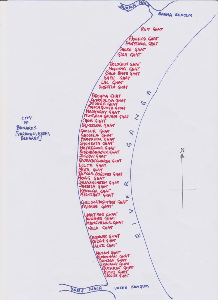
Prinsep marked on the map the numerous ghats on the Ganga River. It cannot be confirmed whether he included all the ghats in existence at his time. The below illustration is copied from the original map. The illustration is not to scale though the names of the ghats are in the exact order as in the map.

James Prinsep’s drawings and illustrations of Benares can be seen in the link below.

https://umedia.lib.umn.edu/search?facets%5Bcreator_ss%5D%5B%5D=Prinsep%2C+James%2C+1799-1840.

The map discussed in this article can be accessed on the British Library Images online collection. The condition of this map is better than the one I have used for this article located in the Asiatic Library, Kolkata.


[1] ‘The late Mr. James Prinsep,’ The Asiatic Journal and Monthly Register for British and Foreign India, China, and Australasia November 1840, Vol 33 new series, September-December 1840 (London, Wm. H. Allen and Co.), pp186-192 https://books.google.co.in/books?id=W6U3AQAAMAAJ&newbks=1&newbks_redir=0&dq=james+prinsep&source=gbs_navlinks_s

[2] The City of Bunarus, Surveyed by James Prinsep, 1822, Asiatic Library, Kolkata.

[3]https://www.academia.edu/12915430/_112_02_Singh_Rana_P_B_2002_Vishveshvara_Antargriha_Yatra_in_his_Towards_the_Pilgrimage_Archetype_The_Panchakroshi_Yatra_of_Banaras_Pilgrimage_and_Cosmology_Series_Pub_2_Indica_Books_Banaras_222pp_72_figures_maps_ISBN_81_86569_30_8_2nded_2011_pp_164_171

[4] The City of Bunarus, Surveyed by James Prinsep, 1822, Asiatic Library, Kolkata.

[5] Google Map of Varanasi

[6] Cantonments of Sikrol and Pandypoor, also the Civil Station and City of Benares, Season 1867-1868, Surveyor General of India, National Library, Kolkata

[7] H. M. Elliot, Supplement to the Glossary of Indian Terms, A – J (Agra: Secundra Orphan press, 1845), 321. https://books.google.co.in/books?id=ThnNjANUtyoC&newbks=1&newbks_redir=0&dq=Benares+gurha+water&source=gbs_navlinks_s

[8] Not clear on the map

[9] Not clear on the map

Ruins and legend of Kam Kandala Temple, Bilhari, Madhya Pradesh

At a short distance from the town of Bilhari, lying scattered in the shrub jungle are the remnants of a massive structure that must have once been a grand temple. Going by the size of just the amalaka (top stone) of the now non-existent shikara of this temple, one can easily establish a pretty accurate scale of the temple. Thousands of stone pieces with carvings which are now largely eroded lie all around what was once the main temple structure. When I visited in early 2022, the raised platform of the temple was intact.  On approaching the platform, a couple of broken steps lead to a small square platform which is connected to a larger rectangular platform leading to the mandapam pillars. The floor plan for the temple as given by Alexander Cunningham is shared below. When Cunningham visited the place in the mid-1870s, he writes the following description,

After cutting some bushes, and pushing aside some of the smaller stones, I found that Kam Kandala’s palace was only a temple of Mahadeva, with the lingam and argha still standing in situ in the ruined sanctum. The entrance of the temple faced the west, which is a very unusual arrangement, except where the buildings forms one of the subordinate shrines grouped around a large temple. But this could not have been the case with Kam Kandala’s so-called palace, as it is a large building, 54 feet in length by 32 feet in breadth, with pillars in the mahamandapa, or great hall, 10 feet 8 ½ inches in height. [1]

Source: Alexander Cunnigham, Report of a Tour in the Central Provinces in 1873-74 and 1874-75, Vol 9 (Calcutta, Office of the Superintendent of Government Printing, 1879), Plate VII

But in 2022, there was no lingam nor could I see any argha. I did see a long slab of the stone placed where the lingam should have been. Some stone blocks were placed haphazardly like a jigsaw puzzle though incorrectly to create a short wall. The carvings didn’t align nor did the shape of the stones. The photos below speak loud enough about the poor condition of the site.

The locals of that area called this structure and other structures found in the area as being Kamkandala’s palace which led Cunningham to call it such. During his visit he describes visiting another structure just down the hill, less than a mile to the southwest of the ruins of the first temple, a 200 square feet courtyard “surrounding the ruins of a second temple” which, according to Cunningham, was universally called as the elephant stables (hastal) where Kamkandala is believed to have kept her elephants. 

Now who was this Kamkandala?  Cunningham narrates the following:

In Puphavatinagari (old named of Bilhari) reigned Raja Govind Rao in the Samvat year 919, or A.D. 862. He had a very handsome Brahman attendant name Madhavanal, who was especially skilful in singing and dancing, as well as an adept in all arts and sciences, so that all women fell in love with him. The husbands complained to the Raja and Madhavanal was banished from Phuphavati. He retired to Kamvati, the capital of Raja Kam Sen, who was fond of music and singing, and gave the Brahman a place in his sabha, or assembly. This Raja had a most beautiful woman named Kam Kandala, with whom Madhavanal fell in love, for which he was expelled from Kamvati. He then went to Ujain, and asked a boon from Raja Vikramaditya, who was famed for granting every request that was made to him. The promise was duly made, and the Brahman claimed to have Kam Kandala given up to him. Vikramaditya accordingly besieged Kamvati, and captured Kam Kandala, who was at once made over to Madhavanal. After some time, with Vikrama’s permission, the happy pair retired to Puphavati, where Madhava built a palace for Kam Kandala on the Patpara hill, which is universally identified with the ruined temple of Mahadeva…[2]

Cunningham further adds that the above narrated story is based on a folklore called Madhavanalakatha. The meanings of the names Madhavanal and Kamkandala being “sweet flame” and “love-gilder” respectively. He states the existence of this legend in the library of the Bengal Asiatic Society which was written in C. E. 1530. With the help of Babu Rajendra Lala, he gets the gist of the story.

…[The legend] recounts the amours Madhavanal and Kam Kandala, who are said to have resided at Pushpavati in the neighbourhood of the palace of King Govinda Chandra. In the legend he is called simply Govind Rao, and his date is fixed as Samvat 919 or A.D. 862, if the era of Vikramaditya is meant. But it is more likely that the local Samvat of Chedi is intended, which would fix the date in A.D 1168. It is, therefore, not at all impossible that Govinda Chandra of Kannuaj is the king alluded to. We know, however, that the country north of Bilhari was still in possession of the Chedi kings in A.D. 1158, when the Bharhut inscription was engraved on the rock of Lal Pahar… [3]

On further research, I came across several versions, however with very slight variations, of the same love-story by several authors and playwrights. An author named Ganpati wrote Madhavanal-Kamkandala in Gujarati in A.D.1528.[4] This same source mentions the existence of four versions of the same legend though details such as authors and dates are not mentioned.[5] Two manuscripts, both from early 1800s, on the same legend were listed in the catalogue of the Biblioteca Nazionale (Rome).[6] Another version titled Madhavanal-Kamakandala Prabandha, though written by the same author Ganpati mentioned above. In this version the translator gives the name of the author of this legend as Ganapati who was son of Narasa, a Kayastha residing in Amod, in the district of Bharuch, Gujarat. The legend was written in poetry form which had “2,500 doha couplets (dogdhaka), divided into Eight Parts or Angas.” The date of this manuscript is 1528 A.D. The author of the above source mentions that he later finds another manuscript of the same poem in the Fort library, Bikaner.[7] In A.D. 1584, a decade after Akbar invades Gujarat, Raja Todarmal gets a Muslim writer Alam to write the story of these two lovers in Hindi “for the pleasure of Emperor Akbar, whose exploits were comparable to those of King Vikrama and Bhoja.”[8]

Majumdar presents greater details of the story in his translation:

In the city of Puspavati, where Kamasena rules, lives a Brahmana youth by name Madhava, as ‘handsome as Love’. The women of the town run after him, and the citizens beseech the king to get rid of so fruitful a source of trouble. The king, in a judicious mood, tries to test the intensity of the fascination exercised by the boy by bringing him before his queens. Finding him, however, a danger to his own domestic peace, the king promptly banishes him.

Madhava, wandering from place to place, comes to Amaravati. His extraordinary intelligence immediately draws the attention of the local king, who gives him an honoured place in his court. A courtezan-girl, Kamakandala the favourite of the king, is at the moment exhibiting her first dance in the public. Madhava watches her performance. Admiring her skill in dancing, undisturbed even by a bee which alights on her dress, he presents to her the very betel-leaf which the king had presented to him as a mark of honour.

The king angry at the scant courtesy shown by Madhava to the royal present, orders him to leave the town. The young man with the curse of beauty upon him, while on his way to leave the city, meets Kamkandala.

She invites him to her house. The two meet; both fall in love with each other, exchange spicy riddles and their spicier solutions, and are happy. In the morning both part from each other with breaking hearts.

Madhava goes to Ujjayini, and describes his distress in verses, which he writes on the walls of the Mahakalesvara temple. Wandering in disguise about the city at night, as was his wont, to discover the miseries of his subjects, King Vikrama reads the verses, and he employs an old courtezan to find out their love-lorn author.

Madhava is found, and, is brought to Vikrama. Apprised of the hero’s love for Kamakandala, the reliever of distress forthwith calls upon Kamasena to give her up; and on his refusal to do so, marches upon his city with an army.

Vikrama, however, wants to test the strength of Kamakandala’s love. He goes to her in disguise, and tries in vain to win her for himself. As a further test, he informs her that Madhava is dead. On hearing of the death of her lover, Kamakandala becomes unconscious, and is on the point of death.

The King comes back to his camp, and informs Madhava of Kamkandala’s death. The poor lover also faints.

Vikrama, horror-struck at having killed a Brahmana, and a woman, wants to commit suicide. The spirit Vetala, his friend (so well-known as the hero in the Vetalapancavimsatika– stories) from the other world comes to his rescue, and revives the lovers.

They are married by the King with great pomp; and the lovers live happily ever afterwards indulging in pleasures and pastimes befitting their honoured place in society. [9]

An interesting fact about this poem is that unlike other works where Goddess Sarswati or God Ganesha are invoked at the beginning, here Madana (Kamdeva), the God of Love, son of Rukimini and husband of Rati is invoked.[10]

Madhavanal-Kamkandala being a popular love-story, its hero and heroine have found themselves as subjects of art works of many artists spanning centuries.

Check the following links:

https://www.rct.uk/collection/1005124/rny-khm-khndl-w-mdhw-nl-rani-kam-kandala-and-madhava-nal

https://auctions.pundoles.com/lots/view/1-4TJAW/madhavanala-and-kamakandala-a-wandering-yogi-faints-before-a-princess-by-dalchand

https://www.alamy.com/stock-photo/kamakandala.html?sortBy=relevant

Lintels of the Mandapa of the Temple: Observe beams laid in a hexagonal fashion in the middle opening. This is where the mandapa shikhar would have been located.

[1] Alexander Cunnigham, Report of a Tour in the Central Provinces in 1873-74 and 1874-75, Vol 9 (Calcutta, Office of the Superintendent of Government Printing, 1879), 36-37.

[2] Alexander Cunnigham, Report of a Tour in the Central Provinces in 1873-74 and 1874-75, Vol 9 (Calcutta, Office of the Superintendent of Government Printing, 1879), 37.

[3] Alexander Cunnigham, Report of a Tour in the Central Provinces in 1873-74 and 1874-75, Vol 9 (Calcutta, Office of the Superintendent of Government Printing, 1879), 37-38.

[4] Dr. Nagendra, ed., Indian Literature [Short Critical Surveys of 12 Major Indian Languages and Literatures] (Agra, Lakshmi Narain Agarwal, 1959), introduction p. ix (Visva Bharati Library Santiniketan) https://archive.org/details/in.ernet.dli.2015.97863/page/n19/mode/2up?view=theater

[5] Dr. Nagendra, ed., Indian Literature [Short Critical Surveys of 12 Major Indian Languages and Literatures] (Agra, Lakshmi Narain Agarwal, 1959), introduction p. x (Visva Bharati Library Santiniketan) https://archive.org/details/in.ernet.dli.2015.97863/page/n19/mode/2up?view=theater

[6] Theodore Aufrecht, Florentine Sanskrit Manuscripts (Leipzig, G. Kreysing, 1892), 34-35 https://hdl.handle.net/2027/uc1.b4179662

[7] M. R. Majumdar, Madhavanala-Kamakandala Prabandha, Vol 1 (Baroda, Oriental Institute, 1942), preface. https://archive.org/details/in.ernet.dli.2015.382560/page/n3/mode/2up?view=theater

[8] M. R. Majumdar, Madhavanala-Kamakandala Prabandha, Vol 1 (Baroda, Oriental Institute, 1942), preface. https://archive.org/details/in.ernet.dli.2015.382560/page/n3/mode/2up?view=theater

[9] M. R. Majumdar, Madhavanala-Kamakandala Prabandha, Vol 1 (Baroda, Oriental Institute, 1942), preface vii-viii. https://archive.org/details/in.ernet.dli.2015.382560/page/n3/mode/2up?view=theater

[10] ibid

Ujhla Bridge or Ujhala Bridge, Mirzapur

A small river flowing to the west of Mirzapur disgorges itself into the River Ganges. It intersects the road leading from Mirzapur to Vindhyachal. This is the Ujhla River or ‘Nullah’, as the British referred to it. Though a small river in comparison to the Rivers like Ganges and Yamuna, the Ujhla presented a great deal of hindrance to the travellers wanting to cross it to reach Vindhychal from Mirzapur or vice versa.  This was during the days when there was no bridge across the river.

This article is about the first bridge across the Ujhla, the construction of which was possible because of the munificence of a local high priest. Numerous public works dot our country which were erected due to the large financial contributions of Indian men and women – both known and unknown.

Despite being a small river, the Ujhla presented a considerable challenge to travellers wanting to cross it. The banks of the river are high, nearly 50 feet high and steep on both sides, for about a few kilometres upstream and some metres downstream before the high banks suddenly drop to the level of the rivers. During monsoons the rivers swelled up considerably and with it the sandbank, where the Ujhla met the Ganges, would get flooded for months.

During the British rule, and possibly before that as well, the road connecting Mirzapur and Vindhyachal was an important trade road. Large consignments of goods like cotton and grain loaded on carts made their way to Mirzapur, and from Mirzapur sugar and lac were exported to places like Allahabad and Banda via this road. The immense difficulty the merchants and traders faced in crossing a river with high and steep banks by breaking bulk is not difficult to imagine. Moreover, much before the arrival of EIC to the territories, the Vindhyavasini Temple at Vindhyachal was an important centre of pilgrimage for Hindus. Huge droves of Hindus would make their way to the temple during auspicious days in the Hindu Calendar. Those travelling from the east would have had to cross the Ujhla River and its precipitous banks. A bridge would, undoubtedly, make their journey less perilous.

In the 1830s, an Indian named Bansidhur presented Rs 12,000 to the magistrate for the construction of a bridge across the Ujhla.[1] However that didn’t materialise. Later, another Indian offered Rs 38,000 for a bridge.[2] However, the offer was withdrawn. The engineers who surveyed the river for the possible construction of a bridge reported that it was impossible to erect a masonry bridge across the river since its nature was fickle. Instead, they suggested a suspension bridge for fording the river. The Indian wanted only a masonry bridge and therefore refused to fund a suspension bridge.

It was in 1848, when a plan of constructing a bridge over the Ujhla was taken up earnestly. It so happened that Major Markham Kittoe, an officer with great interest in both archaeology and architecture, visited Mirzapur as part of the team of Lord Hardinge, the Governor General. Kittoe expressed interest in visiting the Fort of Kantit which was situated south of the Vindhyavasini Temple. He was accompanied by Mr Wigram E. Money, the Collector of Mirzapur.[3]

Below is the verbatim account of what followed once they reached the right bank of the Ujhla River:

The banks are precipitous, and their descent and ascent very steep and dangerous; and during the rains the road was often closed for days on account of the violence of the torrent, by which hundreds of lives were formerly lost. The whole of the drainage of the country from the foot of the hills, for miles around, passed through this outlet, and comes down sometimes instantaneously and carries everything with it.

I suggested to Mr Money the great advantage of a bridge. He asked me if I considered it practicable; which I did. He told me many years ago, 38,000 rupees have been given by a native gentleman for that purpose, but that the Engineer Officers consulted, pronounced a masonry work to be impracticable, and wished to have a suspension bridge, which the native refused to subscribe to as being perishable.

Mr Money, ever ready to promote useful undertakings, asked me to put my ideas on paper. We went some way up the nullah examining the banks  both above and below. A sheet of country paper was sent for and a reed pen and ink. I made a sketch of the banks and nullah, and measured the span at a convenient spot, and then sketched a bridge of three arches, little differing from the present structure.

I subsequently at Mr Money’s request, prepared a small coloured drawing and gave a rough estimate; and in less than a week from the date Mahunt Pursaram Geer had promised to build; and had placed 10,000 rupees at our disposal. We at once commenced operations and carried them on under the superintendence of an old European pensioner overseer, and under the care of Mr Money, Major Stewart, Mr C. Hamilton and other gentlemen, who took lively interest in the work, which I visited as often as was necessary to instruct as to the course of operations, and thus has this great structure been carried on to completion.

Going by the information at hand, the construction of the bridge started sometime in 1849. The proposal with respect to acquisition of land for the approaches to the bridge to be constructed over the Ujhla Nullah were submitted to the Sudder Board of Revenue on 23 July 1851. The acquisition of land for approaches to the said bridge on either side of the nullah were confirmed by 5 September of the year.[4]

The bridge was completed in two years or so, the opening happening in 1851. Though when the report on the completion of this project was submitted in 1852, the shops that were planned to be built on the approach roads on either side were still under construction. [5]

The construction of the bridge was done in a novel way to which Major Kittoe laid a claim as being the originator. This construction style, claimed Kittoe, ensured a great saving as also, and more importantly, stability of the structure. Major Kittoe was quite proud of his design and construction plan that he sent a detailed and a larger of it to the Governor General in the hope that he would forward the same to the Court of Directors in London.

The initial estimated cost of the bridge was Rs 30,000 but the cost overshot that by Rs 5000 because of, as Kittoe claimed, the inaccurate estimation of requisite masonry work that entailed. [6]

Major Kittoe gives a detailed account of how he went about constructing the bridge.

My first operation was to dig trial shafts in each bank, which were sunk twenty-five feet; in fact twenty-three below the mud and water-mark of the dry season, and many under the lowest fall of the Ganges, distant 200 yards more or less. A stiff clay, with branches of blue kunker interspersed, was found uniformly to this depth; therefore there was no apprehension on account of the abutments and of the eastern pier. We dug our foundation to 17 feet below the water-mark, and posited our first course on the hard clay. The western pier, however, had to be carried deeper, as the clay was not as firm at the same depth. We had but little difficulty as the water was easily bailed out with baskets and well-buckets, and the clay being so firm generally that the slips were few. Our material, I should remark, has been stone and kunker lime throughout. 

Our work was exceedingly easy up to the spring of the arches, a height of 42 feet from the level of the lowest water-mark and above the foundation; which, as I here shown, averages 17 feet lower, – total 59 feet to the spring of the arches: the spread up and down the stream being 41 feet, and sideways 15 feet.

The piers and abutments are built on the batter, with 5-inch off-sets at every 10 feet, and half an inch in the foot batter. The first three steps, counting from the foundation, upper course (which is 16 feet) are 10 each (as stated above), and the fourth 12 feet, with no batter, except to the cut-waters. At this level the ribs spring from skewbacks cut out of blocks of stone.

The arches of this bridge are segmental, pointed, the radius of the arcs being 36 feet; the versed sine or rather rise, being near one-third or 15 feet for the two side arches of 50 feet span each, and 20’ for the centre arch, which is 60 feet span. The construction of these arches is one peculiar feature of this bridge.

Then Kittoe goes on to describe his experience in building bridges before this one and what design elements he experimented with. He, during his experience of working with Major Willis on the Grand Trunk Road and assisting in building bridges at other places, found that for a masonry bridge to be strong and stable the whole span of the bridge should be divided into several sections, and that for each section the piers need to be constructed of ‘sufficient strength, and of such form as to enable them to act as abutments in themselves, to sustain the pressure of the separate portions’.

The final design of the bridge was Gothic, and it included some unique features. It was not a simple masonry bridge with a road supported by piers. Kittoe’s design resulted in formation of spaces below the road, on the lower level of the bridge. These spaces could be reached by flight of stairs located midway of the bridge on either side of the road. Further, on both sides of the approach roads, two floors of shops were built. One at the level of the road the other one on a lower level as can be seen in the appended illustrations of the bridge by Major Kittoe himself. Today, they are bare shells, some in a state of ruin while some being misused by the public as dumping ground. But 150 years ago, these shops would have witnessed hectic activity, as merchants and traders brought their goods here either to use as storage, transhipment or used as retail shops.  In all likelihood, the lower level rooms were used as storerooms.

Kittoe made tremendous contribution to the understanding of India’s past. He was indefatigable in his effort to search for remnants of ancient buildings and inscriptions. He wrote several papers for the Asiatic society of Bengal on Indian antiquities. Besides, he was involved in the designing and construction of some iconic buildings, like the Sanskrit College at Benares. [7] He designed and built bridges too.

An officer of the 6th Regiment Native Infantry, Major Kittoe, supposedly was a man of a difficult disposition. Earlier, in 1837, he was dismissed from the army by the general court martial for ‘insubordinate, disrespectful and litigious conduct’,[8] but later he was reinstated with the help of his friend, Mr Prinsep.[9] He was of the 6th Regiment Native Infantry.

He died at a young age of 44 years and 5 months sometime in the first half of April 1853,[10] within a year following the completion of the Ujhla Bridge. He took ill in January of the same year when in India and subsequently he put in a request for a furlough to England to improve his health. However, his condition worsened during the voyage back to England.[11] Within three weeks of landing in England, he died at Coddenham, Suffolk.[12]

The Mr E. A. Reade, Commissioner of Benares Division, said of the bridge: ‘Whatever difference of opinion there may be as to the style, or the principle of its construction, the Oojhla bridge is undoubtedly a great public improvement, and promises to be lasting.’ [13]

The Commissioner was right about its lasting usage. For 170 years this bridge has facilitated an unbroken thoroughfare between Mirzapur and Vindhyachal to travellers both on foot and in various types of vehicles. For over 50 years, the heaviest vehicles that plied over the bridge were loaded carts pulled by animal draught. We can add elephants with their mahouts too. It is to the credit of the architect Mr Kittoe, that the bridge has unfailingly taken the weight of motor vehicles for nearly hundred years – even loaded trucks and buses traversed, and continue to traverse, over this same bridge. Not to mention surviving the torrential flow of water during heavy monsoons and floods that the region is prone to.

(Watch this video of the flooded Uljha River: https://public.app/video/sp_ptascbonswl4u)


[1]‘Asiatic Intelligence’, The Asiatic Journal and the Monthly Register for British and Foreign India, China and Australasia, Volume XXVI, New Series, May-August 1838 (London: Wm. H Allen and Co., 1838), p. 25. Google Books Accessed June 2014.

[2] ‘Bridge over the Oojhla Nullah, West of the Town of Mirzapore’, Selections from the Records of the Government, North Western Provinces, Volume III, Part XII to XXI (Agra: Secundra Orphan Press, 1855), pp. 85-86. Hathitrust, accessed on 30 August 2020, https://hdl.handle.net/2027/hvd.32044105328660.

[3] Source hidden by author

[4] ‘Bridge over the Oojhla Nullah, West of the Town of Mirzapore’, op. cit. This is from a cover letter from Mr E. A. Reade, the Commissioner of Benares Division to the Secretary to Government, North Western Provinces dated 2 June 1852.

[5] ibid.

[6] ibid.

[7] A. Cunningham, ‘Introduction’, Archaeological Survey of India: Four Reports made during the year 1862-63-64-65, Volume I (Simla: Government Central Press, 1871), p. xxv. Hathitrust, accessed 18 September 2021, https://hdl.handle.net/2027/umn.31951p010432428

[8] Source hidden by author

[9] A. Cunningham, ‘Introduction’, op. cit.

[10] Source hidden by author

[11] A. Cunningham, ‘Introduction’, op. cit.

[12] Source hidden by author

[13] ‘Bridge over the Oojhla Nullah, West of the Town of Mirzapore’, op. cit.

Sri Mukhalingesvara and Somesvara Temples at Mukhalingam, Andhra Pradesh

Mukhalingam9

Sri Mukhalingasvara Temple – Mandapam  entrance

These are two of the three ancient temples located in the village of the same name as the first temple mentioned in the title. It took many wrong turns to finally get to the right road to this village. When I visited (two years ago) Google Maps was of little help as the temple was marked way before its actual location. In fact, a recently built temple was at the place where Google Maps directed me to and on seeing it, I was disappointed. I had not travelled four and half hours from Vishakhapatnam to visit a new temple. Overcoming language barriers and tolerating the heat, I doggedly stuck to my plan and that helped me find the place. Though by the time I reached Sri Mukhalingersvara Temple it was time for the deity’s afternoon rest, so I found the doors of the sanctum shut. Nevertheless, I was elated to find myself standing in front of this majestic temple. Going past the shining gilded Dhwaja Sthambha, I climbed a couple of stairs to enter the first small enclosure of the temple through the Simhadvara[1] (entrance facing east) and then through a vestibule, which hosts sculptures that depict how Siva revealed himself to Savaras,[2] to enter the main compound in which stands the main mandapam and sanctum, and other smaller temples. I decided to spend my time exploring the beautifully sculpted subordinate temples located on the four corners and, also, two other smaller shrines. The temple was under renovation, so scaffolding obstructed my viewing a few of them from close quarters.


Being a Siva temple, a very dignified sculpture of Nandi graces the entrance of the main building. it is made of black stone and sits on a raised platform under a canopy. On the four corners of the courtyard stand smaller versions of the main temple and all are dedicated to Siva. The gopuram of each possess sculptures that depict characters and scenes from Hindu mythology. Despite being quite worn out, the sculptures are beautifully crafted and embellishments that adorn the exterior of the walls of these temples add to the magnificence. Besides these on the right hand of the main temple is a small temple, rather more of an alcove, dedicated to nine forms of Goddess Durga. This was locked too but I could see the deity made of silver through the metal bars that formed the door.

Goddess MukhalngamMukhalingam

Top photo is of the temple dedicated to Goddess Parvati. The second one is a closeup of the beautifully sculpted walls and entrance of one of the subordinate temples located in the four corners of the courtyard.

The legend behind the origin of the temple as given in Kshetramahamatya.

Brahma, the creator, who is deprived of his divnity, goes to Mahendragiri, a mountain in the Kalinga country, a cursed tract, unworthy to be the abode of an Arya. He undergoes there a severe penance. Siva, who is pleased with his austerities, offers a boon. Brahma requests him to sanctify the Kalinga country by his presence on the bank of the Vamsadhara river, to which Siva assents. The Fates so contrive that certain Gandharvas are cursed by Vamadeva, for an act of indiscretion with the Savara women, to be born as Savaras, but they are to regain their former status on seeing the divine form of Siva which is in time to be revealed to them. So Gandharva-Saravas live in the forest of madhuka tress, to the west of the Mehendra Hill, on the bank of the Vamsadhara, near the city of Jayanta. The Savara chief has a wife and a Saiva concubine of Srisailam. The two women quarrel for a madhuka tree, which the chief cuts off; when lo! The divine light of Siva issues forth from the hollow of the broken trunk… Brahma, Vishnu, and all the gods come to glorify the event. Brahma brings there ten millions of lingas. Visvakarma builds beautiful temples of gold and gems.[3]


The temple doors opened dot at 2 PM and I managed a very fulfilling darshan as very few people were present. The Sanctum Sanctorum is a very tiny room in which the huge swayambhu Lingam occupies a considerable space. After the darshan I tried to get some information from the head priest but again language barrier caused me much trouble. Nevertheless, one important thing I could glean from him was that the temple was built in the fourth century of the Common Era.

Standing on the left bank of the Vamsadhara River and about 20 miles from the town of Parlakimedi. Up until the twentieth century, the Zamindar of Parlakimedi kept the temples in good repair and made adequate endowments for their upkeep. The three temples are dedicated to Siva. This tract was considered as holy as the city of Benares. G. V. Ramamurti, a highly respected Telugu scholar, visited the locality In the 1890s. A few months before his visit, the local Talukdar, at the behest of the Government, made extensive arrangements for the Shivaratri celebrations when thousands of devotees made their way to the temples,[4] confirming the importance of this place as a religious centre till at least the end of the nineteenth century.

Ramamurti gives a detailed account of his findings in the three temples and ruins lying scattered in the area and presents a convincing argument to suggest that Mukhaligam village was once the capital Kalinganagara of the Kalingas.[5] This contention got legitimacy in 1927 when the Andhra Historical Research Society celebrated ‘Kalinga Day’ in the Mukhalingam village. To mark this occasion a commemorative volume titled ‘Kalingadesacharitra’ written by the R. Subba Rao was released.[6] Subba Rao in his another article mentions that many inscriptions record land grants by public officials to the deity called ‘Kalingavani Nagare Srimanmadhukesvaraya’ which shows that Kalinganagara or capital of the Kalingas was this village.[7] The earliest name of the village was Jayantapuram, and since the idol in the Mukhalingesvara temple is referred to in the inscriptions found on the walls of the temple as Madhukeshvara, the village was called Madhukesvaram and its name was changed to Mukhalingam a few years before Ramamurti’s visit.[8] But Ganjam District accounts published previously to his visit refer to the place as Mukhalingam and not as Madhukesvara.[9] This Mukhalingam village is identified as Moccalingam mentioned in Pliny’s account of India.[10]

Ramamurti discovered some inscriptions on the walls of the Mukhalingesvara temple which were accidently exposed when plaster covering them came off over a period. Thus, other inscriptions still lie hidden behind the plaster that form the covering of the ancient original walls and therefore are not available to expand our understanding of the history of the temple and its surroundings. Those few inscriptions that have been revealed by the coming off of the plaster reveal the name of King Anantavarmadeva (Anantavarma Chodagangadeva) as being the ruler during the time when significant private donations of gold, land or money were made to the temple.[11]

One of the intriguing finding by Ramamurti from among the eleven exposed inscriptions was that one of the inscriptions was in Bengali Nagari characters. This he found on the southern gateway of the temple. Ramamurti could not read this inscription so we have no clue as to its contents. Regretfully, I was not able to see the inscriptions inside of the temple as it was dimly lit and, also, photography was prohibited. The finding of a Bengali inscription is exciting because it raises several important questions. Who were the people who visited this place from Bengal? Did Bengali traders make their way this far south? What were the goods or products they traded in? Was Mukhalingam a flourishing mart or a place of production of something important? Or was it that this temple was an important place of pilgrimage those days which drew devotees from Bengal? It is extremely vital that more inscriptions should be unearthed from behind the plaster to further our understanding of the Ganga Dynasty, or even their predecessors the Kalinga, as also the socio-religious conditions of the time. Not only does this apply for the area in which these temples are located but also for other regions from where people or traders flocked to this place. This possibility is confirmed by the inscription in Nagari characters located on the wall of the storeroom right next to the garbagriha.[12] Such findings increase the likelihood of the existence of inscriptions in other languages and scripts, and also from a far ancient time, behind the plaster. According to R. D. Banerji, the temples and ruins in the area extending to the sea near Kalingapatnam suggest that these belong to the early centuries of the common era when the Kalingas ruled over the area. Banerji contends that some remains of the Kalinga empire go back to the first and second century BCE. One of these remains is the temple at Mukhalingam.[13] According to Douglas Barrett, the oldest amongst the three temples is Sri Mukhalingesvara Temple. Barrett quotes Ramamurti extensively in his short article on the temples but disagrees with him on the question of the oldest temple.[14]

Subba Rao, an accomplished scholar whose focus of study was the Kalingas, has written extensively on the copper plate inscriptions and about their bearings on our understanding of the Kalingas and their successors the Eastern Ganga dynasty that ruled over an area encompassing modern north Andhra Pradesh and south Orissa – the area falling within the Ganjam and Srikakulam districts.[15] He provides a detailed analysis of epigraphic sources found in the area and agrees with Ramamurti’s inferences of the temples. Similarly, H. C. Ray presents a detailed account of the Ganga dynasty based on epigraphic sources found at Mukhalingam.[16]

Ganga Kalinga Dynasty

Mukhalingeswar Plan
 

Layout of the temple complex.


As for the rest of the inscriptions studied by Ramamurti, Anantavarmadeva finds mention in several. The years mentioned in the inscriptions range from Saka 1004 to 1100 and Anantavarmadeva is mentioned in the ones dated 1004 and 1042 Saka,[17] indicating his years of reign. Ramamurti states that the antiquity of the temple could be older because some inscriptions of older characters were found which he was unable to read.

The four subordinate temples located on the four corners of the compound are dedicated to dikpalakas (guardians of the directions) – Indresvara (southeast), Angesvara (southwest), Yamesvara (Northwest), and Varunesvara (northeast). The temple is without a pradakshinapath so is a nirandhara style of temple.[18]

On the left is Yamesvara Temple and on the right is Varuneswara Temple. Both are subordinate temples to the main one.


The Someswara Temple located short of a kilometre from the first mentioned temple, opens to the west. This is a peculiarity, according to Ramamurti. The structure that still stands today is just the garbagriha, therefore a much larger complex would have existed, as deduced by Ramamurti from the existence of stone debris lying around the temple.[19]

He mentions that part of the top part of this temple was damaged by lightening some time before his visit. According to him, the construction of this temple calls for special consideration as it a rare form of architecture. The temple is built with loose sculpted stones which are placed skilfully to fit into one another like a jigsaw puzzle without the aid of cement like substance. The style of the temple is Orissa style.

Somesvara Temple: The photo on the left is of 1981 from M. Krishnamurthy, ‘Some Important Temples of Andhra Pradesh’, in Itihas, Journal of Andhra Pradesh State Archives, Volume III, no. 1 (1981), Plate VII, pp. 159-172. The one the right was taken by the author of this article in 2018.

Everything here is skillfully executed. The carvings are all of exquisite workmanship and elaborately ornamented. The figures, representing various deities of the Hindu mythology, are excellent specimens of Hindu sculpture, tastefully executed, graceful in form, and chaste in design. Each of these deities occupies a splendidly carved cell or niche standing in bold relief; in some cases it is a monolith, in others it is formed of loose stones fitted into one another. The forms of these niches are various, triangular, circular and so on. The gateway is surmounted by an excellent frieze, representing the Navagrahas, the nine Hindu planets – very beautiful figures.[20]

Somesvara Temple Nine Planets

Nine Planets or Navagraha on the doorway

Some of the sculptors of gods and goddesses in niches on the exterior wall of Somesvara Temple


Ramamurti contends that this temple to be the oldest of the three temples located in Mukhalingam. Based on the inscriptions, the temple structure and architecture, and mythological account in the Kshetramahatmya, Ramamurti came to the conclusion that Mukhalingam village had been in existence since the eight century of the common era, and he credits the Ganga Prince Kamarnava for having founded the town. Another prince of the same dynasty and same name as Kamarnava built the temple in the ninth century. By the twelfth century, during the rule of Anantavarman, the place achieved a flourishing status. He further adds that Prince Madhukarya repaired that temples in the fourteenth century. All the named princes belonged to the Ganga dynasty, and so did the zamindar who was in possession of the temples at the time Ramamurti visited which led Ramamurti to conclude that Mukhalingam temple and the town had been in ‘uninterrupted possession’ of the Ganga Dynasty and its descendants for eleven centuries. [21]

References

[1] Ramamurti, Gidugu Venkata, ‘An Account of the Antiquities of Mukhalingam and its Neighbourhood’, in Madras Journal of Literature and Science for the sessions 1889-94 (Madras: Madras Literary Society and Auxiliary of The Royal Asiatic Society, 1894), pp. 68-102.
[2] ibid.
[3] ibid.
[4] ibid
[5] ibid
[6] Journal of the Andhra Historical Research Society, July 1931, Volume VI, Part I, p. 3.
[7] Rao, R. Subba, ‘The History of the Eastern Gangas of Kalinga, Chapter 2’, Journal of Andhra Historical Research Society, Volume VI, July 1931, Part 1, pp. 57-62. Another group of scholars claim that Kalingapatanam was the capital of the Kalingas. For example, read G. Ramdas in Calcutta Review, March 1931 issue.
[8] Ramamurti, Gidugu Venkata, ‘An Account of the Antiquities of Mukhalingam and its Neighbourhood’, in Madras Journal of Literature and Science for the sessions 1889-94 (Madras: Madras Literary Society and Auxiliary of The Royal Asiatic Society, 1894), pp. 68-102.
[9] Maltby, T. J., G. D. Leman, ed., The Ganjam District Manual (Madras: W. H. Moore, 1882), p. 62.
[10] Rao, R. Subba, ‘The History of the Eastern Gangas of Kalinga, Chapter 2’, Journal of Andhra Historical Research Society, Volume VI, July 1931, Part 1, pp. 57-62, pp. 59-60 fn.
[11] Ramamurti, Gidugu Venkata, ‘An Account of the Antiquities of Mukhalingam and its Neighbourhood’, in Madras Journal of Literature and Science for the sessions 1889-94 (Madras: Madras Literary Society and Auxiliary of The Royal Asiatic Society, 1894), pp. 68-102.
[12] ibid.
[13] Banerji, R. D., History of Orissa: From the Earliest Times to the British Period (Calcutta: R. Chatterjee, 1930), p. 11.
[14] Barrett, Douglas, ‘Mukhalingam Temples’, in Heritage of Indian Art Series 2 (Bombay: Bhulabhai Memorial Institute, 1960), pp. 1-12. Barrett was a curator in the British Museum London and wrote on art and architectural antiquities of the Indian continent. Barrett mentions that there are hundreds of inscriptions on the temple walls which means plaster cover has been removed at most places to uncover more inscriptions since the time Ramamurti visited this temple in 1890s.
[15] See R. Subba Rao, ‘The History of the Eastern Gangas of Kalinga, Chapter 2’, Journal of Andhra Historical Research Society, Volume VI, July 1931, Part 1, pp. 57-62; ibid, Chapter 3, Part 2, October 1931, pp. 69-86; ibid, Part 3 and 4, January and April 1932, pp. 193-216; R. Subba Rao, ‘The Administrative System of the Early Eastern Ganga Kings of Kalinga from the close of the 5th Century A. D. to the close of the 9th century A. D.’, Proceedings of the Indian History Congress, Volume 5, (1941), pp. 187-194. JSTOR,  accessed 23 July 2020.
[16] See H. C. Ray, The Dynastic History of Northern India (Early Medieval Period), Volume I (Calcutta: Calcutta University Press, 1931).
[17] Ramamurti, Gidugu Venkata, ‘An Account of the Antiquities of Mukhalingam and its Neighbourhood’, in Madras Journal of Literature and Science for the sessions 1889-94 (Madras: Madras Literary Society and Auxiliary of The Royal Asiatic Society, 1894), pp. 68-102.
[18] Krishnamurthy, M., ‘Some Important temples of Andhra Pradesh’, in Itihas, Journal of Andhra Pradesh State Archives, Volume VIII, no. 1 (1981), pp. 159-172.
[19] Ramamurti, Gidugu Venkata, ‘An Account of the Antiquities of Mukhalingam and its Neighbourhood’, in Madras Journal of Literature and Science for the sessions 1889-94 (Madras: Madras Literary Society and Auxiliary of The Royal Asiatic Society, 1894), pp. 68-102.
[20] ibid.
[21] ibid.

The Kings of Mandala of Central India: A Genealogical Account

A dynasty/kingdom called Graha Mandala ruled over eastern parts of Central India and their territory lay along the banks of the Narmada. Their first capital is said to have been Garha, now part of the city of Jabalpur. However, Alexander Cunningham, based on his understanding of the Kalachuri Inscriptions, says that the Chedi dynasty ruled over this area, their capital being Tewar or Tripura close to Garha.[1] I have tried to locate this place with the help of Google Maps but I haven’t been able to find such a place near Garha or Jabalpur. Cunningham locates the early Gond territory near upper Narmada region comprising of Mandla, Ramgarh and Shahpur, ‘with the whole, or greater part, of Balaghat’.[2]  The tenth king (genealogical list given below) Gopala is said to have built Gopalpur to the west of the early seat Garha.

In 1830s, E. Fell found an inscription at Graha Mandala and from the translation he found a complete list of rulers of the region. Fell theorises that the fifty two kings before Hridaya, who became king in 1617, would have reigned twenty years each which would then take the origin of the dynasty to 1040 years from the date of Hridaya. Consequently, the first king, Yadava Raya would have ruled in circa AD 627.[3]

In 1860s, Fitz-Edward Hall, in his article wrote a commentary on the inscriptions and also provided the facsimile of the inscriptions along with his translations. In this article Hall mentions that some years after E. Fell’s contribution, which was published posthumously, Sir Henry Sleeman expanded on the genealogical study of Gond rulers.[4] Sleeman retrieved some local documents comprising of two manuscripts in the ‘Hindi language, of anonymous authorship’ which gave an account of the Mandala rulers.[5] Hall possessed the copies of these two manuscripts and bases his account and analysis of the rulers on these two and also of the account given by Ferishta.

Hall states that according to the manuscripts, the copies of which he possessed and which were referred to by Sleeman, the earliest ruler of Mandala were Haihaya Rajputs, descendants of the ‘thousand-armed Arjuna’. Hall relates that according to a story then current, a copper plate with inscription was found in the days of the rule of Nizam Shah (60th ruler) dated AD 143.[6] According to this copper plate the territories ruled by the Mandala rulers included Ratnapura, Lanji, and Mandala. Upon extinction of these Rajput families, the Gonds took charge of the area.

It is interesting to note that in time due to matrimonial alliances the lineage became a Gond-Rajput line of kings, as described by Sleeman. Though, Alexander Cunningham, fifty years later, discounts this romantic story. I would, however, like to narrate it here for my readers to make their own inference.[7] The story goes that Mahishmati of the Gonds one day decided to repair to Amarkantak for ‘ceremonial ablution’. Amongst his train of followers was one Yadava Raya, a Kachhwaha Rajput of Khandesh. While on night duty as a sentry in the camp, he noticed the movement of two men and a woman who he presumed to be Gonds, and he noticed a monkey following them after dropping a peacock feather. During his sleep later on, Narmada River in the form of a Goddess appeared in his dream. She informed him that the two men and woman were none other than Ram, Lakshman and Sita, and the monkey was Hanuman. She advised him of his propitious fortune of having seen the revered family in real and that the dropping of the peacock feather, which is worn on the heads of Gonds, as being indicative of his defeating the Gonds and taking rein of the territory. He was directed to move to the state of Garha (written as Gadha in the source) and get in service of the ruler Nagdeo[8] there, and should, by and bye, gain full confidence of the ruler who would in due course of time voluntarily demit power in his favour. In this endeavour he had to take the help of a Brahmin named Sarve Pathaka who must be rewarded with the post of a premier. And so the story goes that Yadava Raya travelled to Garha where after gaining the Garha King’s confidence, he was offered the king’s daughter Ratnavali’s hand. Yadava apparently was a widower and due to mismatch of caste between the two parties, Yadava turned to the Brahmin for guidance. Sarve Pathaka gave assent to the marriage on the conditions that the bride and groom would never eat together. The Garha ruler was agreeable to the condition and Yadava was married to the daughter of the ruler of Garha which marked the beginning of Gond-Rajput lines of descendants. Soon the aging ruler decided to renounce his kingship in favour of Yadava. The ruler of Garha retained the revenue of five villages for his maintenance.[9]

Yadava was crowned king most probably in Samvat 415 corresponding to A.D. 357. Sarve Pathaka was made the Prime Minister. Yadava ruled for five years and in those five years he extended the territory of his kingdom to the Gaura River on one end and River Hiren on the other end. It is believed that Sarve Pathaka’s descendants continued to serve the subsequent Yadava’s descendants in various capacities. The Bhar Vajpeyi clan trace their lineage to Sarve Pathaka.[10]

Hall in his article published the facsimile of the inscription found in Ramnagar in the Mandla district of present day Madhya Pradesh. E. Fell translated the inscription which was published after his death. H. H. Wilson wrote the following comment on the finding of the inscription and its translation:

The Garha Mandala inscription is remarkable for the genealogy of a race of princes who exercised the sovereignty over part of Central Hindustan, in which the enumeration much exceeds that of any inscription yet discovered.[11]

The complete facsimile of the inscription and its translation by E. Fell are appended at the end of this article.

Later in the 1880s, Sir Alexander Cunningham published in detail Sleeman’s finding on the Gond rulers. The chart below gives the complete list of kings as per the inscriptions and also the kings that reigned after the last mentioned King Hridayaswara till 1804 when the last ruler Sumer Shah was killed. The table also includes the length of reign as per Sleeman’s information gleaned from a local. There are differences in dates as suggested by Fell and Sleeman in the enthronement of some kings. The table gives the dates as given by Sleeman.[12]

Graha mandal kings

The length of reign of the 26th ruler, Karnnotha Ratna Sena is not clear so two numbers are assigned to him.

Appended below is the inscription which is followed by the Fell’s translation.

Graha Mandal Sanskrit Inscription 1

Graha Mandal Sanskrit Inscription 2

Graha Mandal Sanskrit Inscription 3

Graha Mandal Sanskrit Inscription 4

Graha Mandal Sanskrit Inscription 5

Graha Mandal inscription Eng Translation1

Graha Mandal inscription Eng Translation2

Graha Mandal inscription Eng Translation3

References

[1] Alexander Cunningham, ‘Report of a Tour in the Central Provinces and Lower Gangetic Doab in 1881-82’, Archaeological Survey of India Report, Volume XVII (Calcutta: Office of the Superintendent of Government Printing, 1884), pp. 46-55.

[2] Alexander Cunningham, ‘Report of a Tour in the Central Provinces and Lower Gangetic Doab in 1881-82’, Archaeological Survey of India Report, Volume XVII (Calcutta: Office of the Superintendent of Government Printing, 1884), pp. 46-55.

[3] E. Fell, ‘Sanscrit Inscriptions; With Observations by H. H. Wilson’, Asiatic Researches; or, Transactions of the Society Instituted in Bengal, for Enquiring into the History and Antiquities, the Arts, and Sciences, and Literature of Asia, Volume XV (Serampore: The Mission Press, 1825), pp. 432-469.

[4] W. Henry Sleeman, ‘History of the Gruha Mandala Rajas’, Journal of the Asiatic Society of Bengal, Volume VI, No. 68, August 1837, pp. 623-648.

[5] Fitz-Edward Hall, ‘On the Kings of Mandala, as Commemorated in a Sanskrit Inscription now First Printed in the Original Tongue’, Journal of the American Oriental Society, Seventh Volume ( New Haven: 1862), pp. 1-23 JSTOR https://www.jstor.org/stable/592154 accessed 28 March, 2020.

[6] Fitz-Edward Hall, ‘On the Kings of Mandala, as Commemorated in a Sanskrit Inscription now First Printed in the Original Tongue’, Journal of the American Oriental Society, Seventh Volume ( New Haven: 1862), pp. 1-23 JSTOR https://www.jstor.org/stable/592154 accessed 28 March, 2020.

[7] Alexander Cunningham, ‘Report of a Tour in the Central Provinces and Lower Gangetic Doab in 1881-82’, Archaeological Survey of India Report, Volume XVII (Calcutta: Office of the Superintendent of Government Printing, 1884), pp. 46-55

[8] W. Henry Sleeman, ‘History of the Gruha Mandala Rajas’, Journal of the Asiatic Society of Bengal, Volume VI, No. 68, August 1837, pp. 623-648.

[9] Fitz-Edward Hall, ‘On the Kings of Mandala, as Commemorated in a Sanskrit Inscription now First Printed in the Original Tongue’, Journal of the American Oriental Society, Seventh Volume ( New Haven: 1862), pp. 1-23 JSTOR https://www.jstor.org/stable/592154 accessed 28 March, 2020.

[10] Fitz-Edward Hall, ‘On the Kings of Mandala, as Commemorated in a Sanskrit Inscription now First Printed in the Original Tongue’, Journal of the American Oriental Society, Seventh Volume ( New Haven: 1862), pp. 1-23 JSTOR https://www.jstor.org/stable/592154 accessed 28 March, 2020.

[11] E. Fell, ‘Sanscrit Inscriptions; With Observations by H. H. Wilson’, Asiatic Researches; or, Transactions of the Society Instituted in Bengal, for Enquiring into the History and Antiquities, the Arts, and Sciences, and Literature of Asia, Volume XV (Serampore: The Mission Press, 1825), pp. 432-469

[12] Alexander Cunningham, ‘Report of a Tour in the Central Provinces and Lower Gangetic Doab in 1881-82’, Archaeological Survey of India Report, Volume XVII (Calcutta: Office of the Superintendent of Government Printing, 1884), pp. 46-55

Gift of a steam launch as a ferry to the city of Benares by Maharaja of Vizianagaram

Steam Launch Vizianagram

In 1872, the Maharaja of Vizianagram, who was a well-known and respected benefactor of the city of Benares, presented a steam launch to the city to be used as a ferry across the mighty Ganges. At the time, apart from the Grand Trunk Road whose route was impeded by the River, the railway station of the East Indian Railway, which was the branch station that connected to the mainline from Calcutta at Mughalsarai, was located on the opposite bank of the River. A steam launch thus improved connectivity between the city on the left bank and the GT road and railway station on the right bank.

Built by Messrs. Yarrow and Hedley of Poplar, London, the steamer was 40 ft. 7 in. long and 7 ft. 7 in. wide. The dimensions, thought to be eccentric, were specified by the Maharaja who thought that such ‘uneven dimensions would bring “luck” to the vessel.’ Completed in 1872, the steamer’s hull was made of teak and coppered. The boiler of this vehicle could use either wood or coal and its engines could generate 16 actual horsepower. The weight of the vehicle, along with the cabin situated forward of the boat, was about 5 tons, and could carry 30 passengers. This launch was small enough to be shipped in one piece on the deck of the ship s.s. Emblehope to Calcutta from Britain.[1]

The steam launch was christened ‘Vizianagaram’ as can be seen in the picture above.

[1] Source on request

The Fort of Chunar

Situated on the banks of the venerated River Ganges in the district of Mirzapur, Uttar Pradesh, this fort has a history that goes back to the time of King Vikramaditya of Ujjain who reigned circa 56 BCE. It has witnessed the ascent and descent of several powerful kingdoms and empires, and has been a gateway to Bihar and Bengal for rulers in the north western part of the subcontinent. Other names of Chunar include Chunargarh, Chunda, and Chandalgarh.[1]

Chunar Gur North End Colour BL Online Gallery 1787

Source: William Hodges, Select Views in India Drawn on the Spot in the year of 1780, 1781, 1782 and 1783 and executed in Aqua Tinta, from British Library Online Gallery http://www.bl.uk/onlinegallery/onlineex/apac/other/largeimage68778.html

Chunar From SW Side 1787 BL Online Gallery

Source: William Hodges, Select Views in India Drawn on the Spot in the year of 1780, 1781, 1782 and 1783 and executed in Aqua Tinta, from British Library Online Gallery http://www.bl.uk/onlinegallery/onlineex/apac/other/largeimage68779.html

The Fort, due to its location on the banks of the Ganges and its high elevation, provided great strategic advantage to any ruler wanting to control the critical water highway of the Ganges. The Fort, thus, was one of the most coveted forts of the region.

A pipal (Ficus religiosa) tree located in the fort is believed to be the shrine of Bhartri Nath who was the brother of King Vikramaditya of Ujjain.[2] Several historians contest the existence of a King Vikramaditya of Ujjain, who supposedly reigned in the first century BCE. According to them, this Vikramaditya was a member of the Gupta dynasty that ruled in the 3rd and 4th century CE. If we accept the latter argument, even then the antiquity of the fort is quite remarkable.

In the seventh century of the Common Era, it is believed that Bilagar Deo, the founder of Baghelkhand took control of a large territory from Kalpi to Chandalgarh, which meant the fort came under his rule during the period.[3]

Importance of Chunar as an extremely strategic place along the north-east corridor of north India can be gauged from references made to it during the tumultuous era of medieval India when the expansionist policies of the Delhi Sultanate and later the Mughals towards Bengal required the capture of this fort as an expression of military hegemony. In 1528, Sultan Mahmud Lodi, the chief of Bengal, rebelled against Babur by taking control of Bihar. To bring the rebellion under control Babur set out towards Bengal and on his way he was informed that Sher Shah Suri, on whom he had bestowed many favours, including rewarding him with several parganas, and having given him charge of the territory, had joined the rebels who were planning to capture the Fort of Chunar. Babur made a stop at this fort during his campaign against the rebellious Sher Shah Suri in late 1520s.[4] In 1530, Sher Shah took control of Chunar Fort which is considered by some historians as the beginning of Sher Shah Suri’s aggressive policy that culminated as the ruler of Delhi.[5] Adil Shah, the Afghan ruler and successor of Sher Shah Suri, used the fort as a base from where he despatched Hemu, a Hindu general, with a large force to defeat Ibrahim Shah, another contestant to the throne left vacant by the death of Sher Shah Suri. Subsequent to defeating Ibrahim Shah, Hemu went on to defeat Tardi Beg Khan, a Mughal who was made in charge of Delhi post the death of Humayun by Bairam Khan, the regent to the young king Akbar. In 1545, the fort was taken by the Mughals after a siege of six months. The long siege tells us that the fort was built with strong fortifications. Caunter describes it as having ‘walls protected by towers rising one behind another, and covering the citadel with an impregnable array of ramparts, which were manned by a numerous garrison’.[6]

Gulbadan Begam, daughter of Babur and half-sister of Humayun, and author of Humayun-nama, called Chunar Chunda in her description of Humayun’s march to defeat the Afghans of Bengal.[7] The fort finds a mention in the Ain-i-Akbari which gives the description of the people residing in the area. According to the description, the people had no clothing and carried bows and arrows as weapons, suggesting the fort was under tribal territory.[8] In the eighteenth century, the fort came under the control of the rulers of Awadh.

Closer View of Chunargarh 1795

Source: Unknown artist, ‘North View of the Fort of Chunargarh on the Ganges from across the river’, work dated 1795.  From British Library Online Gallery http://www.bl.uk/onlinegallery/onlineex/apac/addorimss/n/largeimage55031.html

Water Colour Chunar Fort Seeta Ram

Source: Water colour by Seeta Ram, 1814, from British Library Online Gallery work titled ‘Views by Seeta Ram from Benares to Nazibghur Volume III’ produced by Lord Moira afterwards Marquess of Hastings. This painting is titled ‘The Fort of Chunargarh seen from across the River’. http://www.bl.uk/onlinegallery/onlineex/apac/addorimss/t/largeimage55129.html

For the Khaljis, Lodhis and Mughals Chunar Fort was the gateway to the eastern territories of Bihar and Bengal, for the British, however, Chunar Fort proved to be a crucial base from where they led military expeditions to fulfil their political ambition of acquiring territories of north India.[9] It was in the latter half of the eighteenth century post the battle of Buxar that the fort fell into the hands of the British. In the battle between the armies of the British and Shuja-ud-daulah, the Nawab of Awadh, in 1764, the fort was valiantly defended by the Nawab’s forces. However, the Fort was briefly besieged by Capt. Hector Munro of the British Army when he made a surprise attack on the Fort in the middle of the night. But the Abyssinian commander in charge of the Fort was prepared for such an assault and easily defeated the British soldiers who made attempts at climbing the walls in the cover of darkness. The siege of Chunar Fort by the British, however, continued for many months until the Fort of Allahabad fell to the British in 1765. The Abyssinian commander of Shuja-ud-daulah, on realising that his master was in a very disadvantageous situation, surrendered to Major Stibbert on 7 February 1765.[10] Soon after, the British returned the Fort to the Nawab of Awadh who subsequently, in 1772, exchanged it for the fort of Allahabad.[11]

Under British occupation, Chunar Fort housed a magazine of ammunition and provisions for the brigade located at Kanpur.[12] Kanpur was a critical forward military station which was at a distance of over 400 km via a circuitous Ganges channel from Chunar. The British for some years possessed just a narrow strip of territory along the Ganges between Chunar and Kanpur, and since Chunar was within reach from their Bihar territory, it was the best place to locate back-up for their forward posts such as Kanpur in the north-western regions of the sub-continent. At that time any boat passing on the Ganges near the Fort was minutely scrutinised before being allowed to proceed further.[13]

Chunar Garh ISRM 1928 1

Source: The Chunar Fort, ISRM, Volume 1, June 1928.

Chunar ISRM 1928 2

Source: ‘Chunar Fort from the Ganges’, ISRM, Volume 1, June, 1928.

Chunar fort was a refuge and a sanatorium for British soldiers. It also became one of the most secure prisons for the British adversaries and their families. Hastings retired to the fort after the quelling of Raja Chait Singh’s insurrection in 1781. In 1817, the British incarcerated Trimbakji Dainglia (Dengle), a minister of Peshwa Baji Rao II, in this Fort. In the late nineteenth century, some leaders of the Kuka movement of Punjab, which was brutally suppressed by the British, were confined in the Fort.[14]

Endnotes

[1] ‘The Grand Trunk Road – Its Localities’, The Calcutta Review, Volume XXI, July – December 1853, p. 223, pp. 170-224.

[2] The Indian State Railway Magazine, April 1928 to September 1928, June Issue, Volume 1, no. 9, pp. 639-640

[3] W. W. Hunter, The Imperial Gazetteer of India, Volume VIII, pp. 56-58.

[4] ‘Tuzuk-I Babari’, The History of India as told by its own Historians, Muhammadan Period, Volume IV, John Dowson, ed. (London: Trubner and Co., 1872), pp. 218-287, p. 282

[5] S. R. Sharma, Mughal Empire in India 1526-1761, Part I, (Bombay: Karnatak Printing Press, 1934), p. 128.

[6] Hobart Caunter, Oriental Annual, Or Scenes in India(London: Charles Tilt, 1838), p. 198.

[7] S. R. Sharma, Mughal Empire in India 1526-1761, Part I (Bombay: Karnatak Printing Press, 1934), p. 82 fn.

[8] Thomas Pennant, The View of Hindoostan, Volume II Eastern Hindoostan (London: Henry Hughs, 1798), pp. 208-210.

[9] See Sita Ram Kohli, ed., Fort William – India House Correspondence, Military Series, Volume XXI, 1797-1800 (Delhi: National Archives of India, 1969).

[10] William Hodges, P. 57

[11] Thomas Pennant, The View of Hindoostan, Volume II Eastern Hindoostan (London: Henry Hughs, 1798), pp. 208-210.

[12] William Hodges, P. 57

[13] Hobart Caunter, The Oriental Annual, or Scenes in India (London: Edward Bull, 1834), p. 182.

[14] Jaswinder Singh, Kuka Movement: Freedom Struggle in Punjab (Documents, 1880-1903 A.D.) (New Delhi: Atlantic Publishers and Distributers, 1985), p. 200.

A Historical Account of Bridging the Karmanasa River

The name Karmanasa means ‘destroyer of good deeds’. So before giving an account of the various bridges constructed across the Karmanasa River, it is important to relate the mythological story that made this river an inauspicious one for Hindus as well as Budhhists. The ominous quality of the river was one of the primary reasons for Hindus to build a bridge over the river as it formed a major obstacle to cross for those Hindus from the east wanting to visit important pilgrim places such as Benares, Allahabad and Vindhyachal near Mirzapur.

Gautama Budh, while writing about the sanctity of city of Gaya, stated that, ‘by the touch of water of Karmanasa, all virtuous works are instantly destroyed.’ The Padma-Purana relates a long story on the cause of the misfortune addressed to the Karmanasa River:

After Ravana abducted Sita and took her to Lanka, Hanuman and his followers surrounded his fortress and threatened to destroy Lanka if Sita was not returned. Ravana in order to gain protection for his beautiful city Lanka, prayed to Shiva for assistance. The prayer only managed to invoke a goddess who directed him to obtain a Shivling from Kailash Mountain and carry it to Lanka without placing it even once on the ground during the journey. Ravana obtained the Shivling and on his return, near Baidyanath Hill was accosted by Indra in the garb of a Brahmin. Indra and Varuna, the lord of water, concerted together a plan to stop Ravana from succeeding in his mission. Varuna in his invisible entered the belly of Ravana and created immense discomfort causing him to pause in his journey. He called upon the Brahmin who was Indra disguised as such to help him with the Shivling by holding it for the time Ravana took time to recover from the strange and sudden affliction of stomach pain and discomfort. The Brahmin willingly extended assistance and the moment Ravana handed the Shivling to him, he placed the Shivling of the ground, where it immediately became fixed and permanent. Meanwhile, Varuna had filled Ravana’s stomach with so much water that it soon got discharged and formed a river which was called Karmanasa. And, thus, the water of the river acquired the defiling qualities so abhorred by the Hindus.

Another legend, that is often shared, is that a highly aspiring Rajah Trisanku, father of Raja Harishchandra, wanted to achieve an exalted position among the gods in his material body. To achieve this wish, he requested Rishi Vasistha to assist him but the Rishi refused to help him. The Raja then went to Vasistha’s sons who got irritated by his demand and thus cursed him and turned him into Chandala. Angry and humiliated, Raja Trisanku rushed to Rishi Vishwamitra, who was a rival of Rishi Vasistha, for help. Rishi Visvamitra agreed to help the Raja in achieving his desire. He set a big yagna to which all the Rishis were invited. Rishi Vasistha declined the invitation. At the completion of a successful yagna, Raja Trisanku started ascending towards heaven in his material body. However, displeased by this, the gods stopped his entry and kicked him out of their abode. In the battle of egos between the gods and Rishi Visvamitra, Raja Trisanku became stuck in limbo between the earth and the heaven in an awkward position. The anguished caused tears from Raja Trisanku to flow, which formed the Karmanasa River.[1]

The Karmanasa River is nearly 192 km long and flows in a south-north direction to join the Ganges at village Chausa located in the district of Buxar, Bihar. Despite being a difficult obstacle for the movement of people and goods between the territories of Bengal and North-West Provinces, the river was never successfully bridged even though attempts were made.

According to some sources, several attempts were made in distant past to throw a bridge across the said river but every attempt failed which lent credence to the ominous nature of the river. During the reign of Aurangzeb, the Subadar of the Benares district through attempted to create a bridge over the river. This structure was never completed because remnants of an incomplete structure were visible over a century later, in the early nineteenth century. In the middle of the eighteenth century Rai Bhara Mal, who, according to some was a Diwan of Himmat Bahadur, a Gosain leader, and according to others Diwan of Dara Shikoh[2], began another effort to ford the river near the village of Naubatpur, but faced failure like the others in the past. In 1780, the prolific builder of public and religious buildings Ahilya Bai took interest in the matter and directed her workers, who were involved in creating several ghats at Benares, to ford the river at the same spot as that of Rai Bhara Mal. However, there is no evidence of any work done by her workers.

Towards the turn of the nineteenth century, during the period of Mr Duncan at Benares, Nana Fadnavis took serious interest in fording the river and put in nearly ten years of labour and over rupees fourteen lakhs (some doubt this figure and state in reality it was between rupees two to three lakhs). His death put a sudden stop to the effort. Nevertheless, in those ten years, Nana Fadnavis was successful in creating secure foundations in river which had a ‘soil formed of deep oozing sand.’ To build houses and other construction work, Zamindars and villagers of nearby places carried away parts of the large quantity of material collected for the construction of the bridge. Some were used to built a large well in a village in the vicinity.

In 1820s, public-spirited Indian elite Raja Shiv Chander Rai hired the services of Mr Colin Shakespeare, an engineer in the service of the East India Company, to construct a rope suspension bridge across this river. The British government supported and lauded this effort.[3] This bridge had a 300 feet span and could accommodate foot passengers and dak runners. The coir rope used in the construction of this bridge was tarred to give it extra strength.[4] Soon it was felt that this rope bridge should be replaced by an iron bridge, for which a person was deputed to do a study for its erection. However, the idea was dropped and in its place, it was felt prudent, to build a masonry bridge.

Rai Patni Mal of Benares volunteered the building of this masonry bridge. Rai Patni Mal was known for his munificence towards erecting ghats, tanks, and temples at places like Benares and Mathura. He offered to complete the bridge started by Nana Fadnavis but his family were not supportive of this project as they feared some bad omen might befall him and large sums of money would be wasted on a fruitless project. Rai Patni Mal, however, stood his ground. At the commencement of the project his wife expired, which could have been taken as an evil omen, but Patni Mal was undeterred. The government, also, by then had not accepted any of the terms under which he had offered to build the bridge. The terms were:

1) Permission to use the materials formerly collected

2) Assistance from the police in procuring carts, &c

3) The Services of a Secretary to the Benares Committee of Improvements, who had furnished a design for the new bridge

4) A remission of the heavy duties on Chunar stone

5) A confirmation of the title of Raja Bahadur Neknam, which had been conferred upon him by the king of Delhi, during Mr Seton’s residency[5]


Point number four above was addressed by the opening a quarry nearby instead of carting and paying duty on the stone from Chunar. This quarry was located fourteen miles to the south-west of Naubatpur.

Bridge over Karmanasa River

Source: Gleanings in Science, October 1831, Volume III, January to December 1831, pp. 297-300.

The details of the bridge are given below. Rai Patni Mal executed two changes to the original plan, which is displayed in plate given in the source. The first change he made was to omit the semi-domes over the recesses on the piers and, the second change was to create plain parapet on the wing walls instead of a balustrade.

The original native bridge was to have seven arches of 17 feet span; to take advantage of the piers already built it was determined to throw two of these into one, making three equal arches, which with the piers should occupy precisely 200 feet in span. The semicircular form was preferred on account of the great rise of the river, the necessary height of the road way, the symmetry of the elevation, (since for more than 8 months of the year, the level of the water remains 2 steps below the spring of the arch as shewn in the sketch,) and the convenience of cutting the stones to one model. The span of the arches is 53 feet, and the depth of the voussoirs 3 feet. A vault of brick is laid over them to prevent any infiltration of water through the joints from above. To the piers is given a section of 30 by 13 feet: the roadway is 25 feet wide, and perfectly horizontal. The centering consisted of 6 frames, each composed of four pieces (fig. 3) so as to be as light as possible; for it must be remarked, that no machinery could be employed in the construction: – every stone was to be raised and posited by direct human labour; – figures 5, 6, and 7 are intended to exemplify one instance of this in the simple native mode of carrying stones: the number of men is increased according to the weight to be lifted, and from the combination of levers, the weight necessarily bears equally upon the supporting shoulders of all the pesrajes or carriers; with a saugar of 16 men they readily move a stone of as many maunds or about fourteen cwt.[6]

When the construction started it was found that the coffer dams or kothi of stone had been laid across the bed of the river for a width of 60 feet thereby constructing a solid rock bed.[7] Most of these kothi reached 20 feet below the bed of the river, firmly standing on hard clay. Some of these kothi of stones were filled with masonry which reduced the time and effort in building piers on them. In April of 1830, the first arch ‘was turned’ and two other arches were commenced. And by July of 1831 the roadway was nearly completed. This despite the fact that on one occasion a sudden rise of water by 26 feet carried away parts of arches under construction.

The estimated cost of the bridge as incurred by Rai Patni Mal was Rs 100,000. This was exclusive of the cost incurred by Nana Fadnavis previously. It is reported than Rai Patni Mal’s son, Rai Ram Kishen acted as the superintendent of the project which ensured proper management of funds. Captain Grant, an officer of EIC in the Benares Division, gave valuable advice and inputs in the construction and frequently visited the site to ensure proper execution of the works. However, the whole detail of construction was conducted by Indian masons, and the construction quality was so good that the British officers commended the skills and exertions of the Indian masons.[8]

This masonry bridge still stands (the bottom one) as can be seen in this Google Map snapshot.

Google maps of Bridge over Karmanasa

Source: Courtesy Google Maps.

[1] Wopendranath Ghosh, Rohtas Garh (Cuttack: Orissa Mission Press, 1908), pp. 4-5.

[2] H. M. Elliot, The History of India as told by its own Historians: The Mohammadan Period, Volume VII, ed., John Dowson (London: Trubner and Co, 1877), p. 168.

[3] Colin Shakespeare, ‘Portable Bridge of Suspension,’ in Transactions of the Society, Instituted at London, for the Encouragement of Arts, Manufactures, and Commerce, Vol. 43 (1824), pp. 160-182.

[4] ‘Summary of the Latest Intelligence from the East,’ in The Oriental Herald, Vol. VIII, January to March, 1826 (London), pp. 353- 376.

[5] Gleanings in Science, October 1831, Volume III, January to December 1831, pp. 297-300.

[6] Gleanings in Science, October 1831, Volume III, January to December 1831, pp. 297-300.

[7] The kothis of stone rested upon a wooden frame or jamwat, which is sunken through the sand by the process of under-digging, as practised by the well-diggers of Bengal.

[8] The Caramnassa Bridge, Gleanings in Science, No. 34, October, 1831, January to December, 1831, Volume III (Calcutta), pp, 297-300.

The Bilhari Fort

(To protect my work from plagiarism, I have decided not to disclose my sources. Check profile for info)

A small town called Bilhari, located in the Katni District of present day Madhya Pradesh, once had an impregnable fort. The town is supposed to be very ancient since during the British rule explorers described the place as having numerous ruins of ancient temples and step-wells. In the past, the town was supposedly called Babaot Nagri or Babaotee, and then Papaot. The inhabitants of the place were of the belief that the name Bilhari was derived from a kind of Pan (Betel Leaf) that grew in abundance in the area. In 1873-74, fifteen years after the destruction of the Fort, A. Cunningham, who was the Director General of Archaeological Survey of India, toured the area and gave an account of the ruins of Bilhari. By then the British referred to the place as Bilhari. According to Cunningham, Bilhari was founded by Raja Karn Dahariya at the time of Bhartri or Bhartrihari, the brother of Vikramaditya. It was called Puphavati or Pushpavati (the town of flowers). This name lasted until tenth century of Samvat and was superseded by Bilhari.

The fort that was located in Bilhari was built of red sandstone quarried from the spurs of the Kaimore Range which bordered the same district. It was built by Luchmann Singh Pudhae Chutree in AD 1489 and destroyed by Capt D. C. Vanrenen in August 1857. The order to destroy was given by Major Erskine, Commissioner, Saugor Division. Records of 1874 show the name as of the ruler as Lakshman Sinh Parihar who lived in the tenth century.

According to sources, several centuries ago the town had a circumference of 24 miles, which suggests that it was an important flourishing town of the region. The centre of the town had a building, which was in all probability a town hall. From this building, in middle of the eighteenth century, the Deputy Commissioner of Jabalpur removed a stone etched with the names of thirty seven rulers of the area. The last one mentioned in the list was crowned as ruler in 1758 AD. It is also believed that Aurangzeb had visited this city during his reign and was responsible for getting many of the temples demolished and statues disfigured.

During the First War of Independence of 1857, the Bilheri (Bilhari) Fort was occupied by a group of rebels under Raghunath Singh Bundela of Panna. As soon as the British authorities became aware of this, they sent troops from Jabalpur and Nagod to attack the place. However, the rebels had decamped before the troops arrived. Nevertheless, the British decided to destroy the Fort.


This Fort was situated ‘56 miles N. N. West of Jubbulpore.’ However, the location of the village is to the north east of Jabalpur, just about 15 km west of Katni (called Murwara Katni).

Present day location Bilheri

Source: Google Maps – Screen shot taken on 3 March, 2019. The name of the town is Bilhari and the location of the tank on the east of a set of old structure suggests that this was the location of Bilhari fort. Some fairly recent social media posts show the an old temple in the said location which corresponds with the layout map of the fort given ahead in the article. 


The description of the Fort by its destroyer Captain Vanrenen is critical for our understanding of its condition and situation before it was consigned to gun fire. Vanrenen wrote that the fort was square in shape with a side of 234 feet. At the corners stood circular towers of diameter of 14 feet. The principal gateway had “octangular bastions, one on each side.” The north wall of the Fort was irregular and was in line with an “impassable swamp.” The ends of the wall had towers. To the east, there was an unfordable tank. The only clear space to reach the Fort was in front of the principal gateway, which was located in the south. The south and west were protected by deep ditches that were 12 feet deep and 30 feet wide.

The walls of the square redoubt, were about 40 feet high, and 4 ½ feet thick, the bastions being 10 feet higher, and the whole was carefully loopholed for musketry fire. The fire through these loopholes was obtained from the roof of a line of buildings, or verandah, open at the rear. This banquet was of great solidity, being supported on cut stone pillars. Single stone slabs spanned these pillars, which were faced with line cement.

The northern wall, which faced the swamp/jheel, was 25 feet high and 3 feet thick. Just behind this wall was another wall that was 5 feet thick and higher than the first wall. The difference in height was sufficient enough to send musketry fire over the first wall. The “curtain wall,” which connected this second wall to the square redoubt, was 18 feet high and 5 feet thick. The material used for these walls was stone and lime cement. Capt Vanrenen writes that ‘all the works were of immense strength… and were found [by him] to be in excellent preservation.’

He goes on to describe the interiors:

The open colonnade, with a few interior apartments, would have afforded ample cover for a large body of men, with space for their supplies. Water was obtained from the pucka well within the works, with an additional supply from the eastern tank, by means of a flight of stone steps leading down to it.

Bilheree Fort boasted of an Aamkhass, or Audience Hall, which with some interior apartments, occupied a space of 78 feet by 51 feet. This was a fine hall of elegantly shaped stone pillars, supporting a roof also of stone slabs and lime cement.

Situated in nearly the centre of the redoubt was the Ranee’s or Queen’s apartment, a two- storied building 78 feet by 68 feet. This and the Aamkhass were of the most solid construction.

A place of worship was provided (contained within a rectangular enclosure) in front of the Aamkhass.

The Captain believed then that the walls and fortifications would have held on for a considerable period of time against attack and they would have even “resisted the action of field guns.” According to him, “without guns of come calibre the place was unassailable from the north and east, and (unless the attacking party first occupied the town of Bilheree, which is within range of musketry fire) it was unassailable from the west.” Nevertheless, in order to make the Fort “untenable, and uninhabitable,” Captain Vanrenen managed to completely destroy the walls on the south and south western parts.

Bilheree Fort map

Source: Withheld. The map is copied from a black and white facsimile of the original printed in a nineteenth century periodical. 

According to papers recovered by the British from the Kanungo Mundlah Ram, Lakshman Singh held a jagir from the Nagode Raja which consisted of three hundred villages and which went on to form the Pargana of Bilheri. Lakshman Singh and his descendents possessed the jagir for seventy years, that is until 1559. In 1559, the jagir was taken by “strategem” by Gond Raja Mugru Duj who had married the grand-daughter of Lakshman Singh. The Gonds under the Mundlah chiefs retained the jagir for 115 years. Failure to pay taxes levied by the Mundlah Raja, the jagir was taken away and given to Jaswant Rao Maratha in 1674. Jaswant Rao held the government under the Mundlah Raja. On his death, Jaswant Rao’s son, Munga Rao took charge and reigned for 78 years. In 1742, when the Mundlah Raja was at war with the Raja of Nagpur, Mundlah Raja suspecting Munga Rao of treachery got him killed and transferred the jagir to his favourites Nawab Ajeet Khan and Ahmad Khan. On the deaths of these latter two in 1767, the jagir of the place lapsed to the Mundlah Raja who managed it on his own and derived yearly revenue of 20,000 rupees. In 1779, the Sagar Raja Balwant Rao Pundit defeated and ousted the Mundlah Raja and he soon lost the place to Raghoji of Nagpur. In 1816, the British took control of the area.


Addendum

I visited Bilhari in early 2022. Took photographs of the remains of the fort. The remnants of the old fort are very few. There are no surrounding walls left except for a small section with some steps leading up. No moat exists but where it would have been, if we check with the map posted above and with Google maps, a road has come up over the moat on the south side of the site. Part of the Queen’s apartments still stands. Its a two storied building with steps leading up to the first and second floor. There is passage going to some basement. It was too dark inside so didnt venture in. Adjacent to this, with some gap, is a building which houses the Bilhari Police Station. No sign of the main gateway of the fort, but the present day business of Vinayak Hero Motors sits right where gateway would have been. The lake is nearly dry. However, steps from the inside of the fort leading to the lake are still intact but in a dilapidated condition with garbage thrown all around. These steps are marked in the layout of the fort given above. Beautiful columns still stand though some are broken/damaged due to neglect. Here and there lie stone statues and sculptures, some painted with cream coloured paint which hide whatever intricate carvings these pieces have on them. Unfortunately, the government body responsible for maintenance of such ruins have placed a board giving incorrect information of the remnants. They believe the ruins are of a “math” (a monastery) and therefore the description, whatever little is mentioned, is rather incorrect.

Interestingly, there is an inscription on one of the pillars of the Queens’ apartments. Picture is attached. The government board mentions what is inscribed. However, what caught my eye was the three-fish symbol with a common head right below the inscription.

Bhojeshwar Temple, Bhojpur

Bhojeshwar Temple, Bhojpur

Bhojpur side Nuggets


On the auspicious day of Mahashivratri, I decided to restart my blog with an article on the old Bhojeshwar Temple that houses the largest Shiv Ling in India. I visited this temple a couple of days ago and was awestruck by the simplicity in the design and the architecture that in fact enhanced the grandeur of the monolith Shiv Ling in the sanctum. This marvel is located at about half an hour’s drive south from Bhopal, Madhya Pradesh.

Built by Raja Bhoja I in the eleventh century (A.D. 1010-55[1]) the temple stood on the banks of a manmade lake created by the same ruler by damming of Betwa and Kaliasot Rivers. It is estimated that the lake covered an area of 250 square miles as it stretched from “Dumkheda, near Bhopal city, to Amoha in the south, and from Chaplasar in the east to Barkhedi in the west.” [2] Map given below shows the location of these places, the first having been swallowed by the city of Bhopal. Ostensibly, Sultan Hoshung Shah breached the dams in the fifteenth century and thus the lake is not to be seen today.

Bhojpur Lake

Map Source: C. Eckford Luard, “Gazetteer Gleanings in Central India: The Great Dam and Temple at Bhojpur in Bhopal State,” The Journal of the Royal Asiatic Society of Great Britain and Ireland for 1914 (London: 1914), p. 309, archive.org.


To reach the sanctum of the temple one has to climb a flight of stone steps to the platform that leads to the temple. This large rectangular platform on the western side of the temple has two small raised platforms covered with chhatris (Gazebo). One has a small marble Shiv-ling and the other has the sculpture of a serpent. Both these are worshipped by devotees who visit this temple. Besides the two chhatri-adorned platforms, there is a third raised but uncovered platform which has a Shiv-ling and serpent figures atop it and on the western side a small alcove houses a deity of Mahadev.

The Archaeological Survey of India (ASI) has set up barricades in the area between the three joined platforms and the main entrance of the temple thus preventing devotees from performing the parikrama (circumambulation) of the marble Shiv-Ling. The main temple itself is at an elevation from the platform and there exists old slabs of stones as stairs, which are both small and quite low from the threshold of the entrance for use of devotees. The ASI has installed two flights of stairs at the entrance for people to conveniently enter and exit the sanctum. Also, ASI should be commended for building a ramp to enable the feeble and the disabled to reach the sanctum without having to climb the large stone steps to the platform.

Standing at the threshold of the sanctum the view is to behold. The Shiv-Ling is set on a large platform which is situated much below the level of the threshold. Stone steps lead to the base of the Shiv-ling where devotees worship the Lingam with flowers and fruits. The single square sanctum has a high ceiling with a dome in the centre. According to Wikipedia, sections of the roof were missing until the beginning of the twenty first century when they were covered by fibreglass. It has been contended that the temple construction was abandoned midway leaving many features incomplete. Archaeologist K. K. Muhammed successfully completed the creation and installation of a missing pillar by sourcing the right kind of stone and by employing trained stone artisans. He also holds the view that a mathematical error by the medieval architect resulted in the collapsing of the roof that caused the abandonment of construction of the temple.[3]

The entrance of the temple is both extremely broad and high, very unlike Hindu temple architecture. Probably the entrance was made so big so as to allow the shifting of the monolith Lingam into the sanctum. Prof. Kirit Mankodi terms the temple intriguing because of several peculiar features. This west facing temple lacks a mandapa (a pillared outer hall for devotees) and instead of a shikhara (a tall spire), which is a standard for Hindu temple structure, this temple has a samvarna (a dome shaped) roof. He echoes the view of Shri Krishna Deva and Prof Dhaky who surmise that this temple was a commemorative temple in memory of a departed person. [4]

The gigantic Lingam and the pedestal on which it sits occupy the whole space between the four pillars on each corner of the room. The space between the pillars and the walls adjacent to them is pretty narrow hardly allowing two people to pass through. However, in a single file devotees can easily complete circumambulation of the Lingam if they wish to.

Inside the temple on the southern wall, ruins of a balcony are visible (photos end of the para). In all probability, if completed this would have extended just over the Lingam to enable the king or other royalty to perform Hindu religious oblations of pouring milk and water on the Lingam as is done by devout Hindus over Shiv-Lings all over the country. Similarly, on the outside of the wall, one can see highly ornate remains of a balcony. Both the balconies are faux balconies as there are no approaches or exits to them. Since the superstructure could not be built, seemingly the stairs leading to these balconies remained unexecuted. The fact that these balconies exist on the inside and outside of the same wall and that to perform oblations on such a gigantic Lingam an elevated approach was necessary, it is highly plausible that the balconies were meant to be functional and would therefore have had stairs leading to them if the construction of the temple had been completed. The northern and eastern walls too have faux balconies on the outside but these truly seem to be faux balconies as on the inside of these walls there are no indications of balconies like that on the inside face of the southern wall. These balconies on the outside face of the northern and eastern walls may have been constructed to present a symmetrical design from the outside of the temple. Surprisingly, Kirit Mankodi has not mentioned the presence of an incomplete balcony projecting from the southern wall towards the lingam, and, therefore, has missed taking into consideration the possibility of the balconies on the outside and inside of the southern wall as being functional features of the final completed temple. If the balconies were meant to be used for rituals then would this temple still be called a commemorative one? Or as Mankodi states, built as a funerary temple?

Bhojpur interior nuggets


in the above photo the incomplete balcony can be seen on the right wall, right behind the column in the foreground. Photo taken by author on 10 February, 2018.

Bhojpur Bracket Nuggets


This photo was taken from the floor of the sanctum. The broken beam located right below the balcony suggests that the balcony was intended to be extended further to reach the lingam. Photo taken by author on 10 February, 2018.


Several European travellers and officers of the East India Company who traversed these parts of central India in the nineteenth century have described this temple in their writings. In a travelogue of 1839, the author mentions that the Gosains of the temple ‘resided in a small court in front of the temple.’[5] In another description of 1847, it is said that the pedestal of the Lingam carried an inscription “achintya dhwaja” which meant ‘the sign of incomprehensible.’ The author also states that the temple possessed four pillars.[6]

A remarkable feature of this temple site is the finding of a large number of stone carvings in various stages of completion in the quarries nearby. Along with the carvings, stones pieces have been found that have plans and names of masons etched on them. These are crucial in augmenting our understanding of the mechanics of Hindu temple construction of the medieval period and before. Also, a ramp used to carry the pieces to the top part of the temple is found on the eastern side of the temple.

Louis Rousselet visited this temple site in the 1860s and has given a detailed description of the temple:

The temple is situated on a high mount, part of which has been converted into a terrace and it is reached by a dilapidated flight is steps, overlooked by the poor buildings of the convent; where, passing under a little doorway, we found ourselves at once before a great façade. A vast pointed gap, the archwork of which has partly disappeared, occupies the centre, leaving the interior of the sanctuary visible; and the façade is very remarkable from the marked contrast of is simplicity and mode of construction with the other monuments of India. Large monoliths not measuring less than from thirty to forty feet in height, standing side by side, form the exterior wall; both sides of which had no other ornament than two heads of monsters, of graceful design, from which issued a chain terminating in a bell. The chain and the bell are well known as being one of the favourite adjuncts of Jain architecture.

I have said that the walls had no other ornaments besides these sculptures, but a short time since they were decorated with statues taken from another ancient temple. A flight of a few steps leads to the threshold of the portal, and then descends again to the base of the sanctuary, which slopes downwards. There you face an altar of such gigantic proportions that it fills the entire temple. It covers, in fact, a surface of forty-four square yards; and this enormous mass composed of three superposed granite monoliths, is finished by elegant cornices.

A staircase, concealed so as not to injure the general effect, leads to the summit of the altar, in the centre of which stands a polished cylindrical stone post, perfectly rounded at its summit, and, at the corners of the hall, four superb monolithic columns support the roof of the temple. These columns are considered by the Indians as marvels of their national architecture; and they maintain that he who has never seen the Bhojepore-ka-khoumbas has seen nothing. It is, indeed, impossible to conceive a more graceful form combined with so imposing a mass. Each shaft, which rests on a pedestal two yards in height, is divided into three equal sections; the first and the second are octagon, and the third had twenty four sides, which has the effect of adding wonderfully to the perspective, and augmenting the apparent height of the columns; and the capital forms a graceful campanile, whence issue heavy consoles, supporting the extremities of the four massive architraves on which the roof rests. It is on this roof, a magnificent concentric Jain dome, that the architect appears to have bestowed all the ornamental riches of which he has been so sparing in the rest of the edifice. Each of the circles of the cupola is a continuous network of lace, flowers, fruits, and arabesques, in the midst of which sport innumerable figures of musicians and dancing girls.[7]


Bhojpur bell nuggets

Photo taken by author on 10 February, 2018. This shows the bell on the chain sculpted on the doorway as described by Rousselet above. The chain and bell column was missing before the repairs as is visible in the photos below. Also, the closeup of the doorway clearly shows the broken part on the top and left jamb.


If we ignore Rousselet’s incorrect ascription of certain features to Jain temples, such as the bell on chain which is an inalienable aspect of a Hindu temple as well, his description of the temple augments our understanding of the temple architecture as well as corroborates other descriptions. From the description given above and from the mention in the 1839 travelogue of Gosains residing in front of the temple, it is clear that the convent which housed the Gosains of the temple existed on the platform that today stands barren except for the three raised platforms mentioned earlier. Since Rousselet calls the convent structures as ‘poor buildings,’ it indicates that the convent structure was not temporary in nature but was possibly made of stone. Thus, when were these convent structures removed, by whom, and why?

Interesting to note is that these travellers noted a saying common among the local people about Raja Bhoj’s contribution to our rich cultural heritage:

Muchalpoor ka baolee our [aur] Bhojpoor ka Kumbh

Udayapoor ka Dehura (was built by one man)[8]

‘Kumbh” here refers to the imposing tall pillars of the Bhojeshwar Temple.

Even more interesting is the description written in the early twentieth century. In an article written in 1914, the courtyard in front of the temple is described as nothing but a long and narrow “collection of mud and rubble.” This narrow courtyard extended to enclose some small “huts used by the local Mahant and his chelas.” Interestingly, in this description the author mentions the existence of four pillars within the temple.[9] Thus, the destruction of the pillar gets pushed to sometime after 1914.

As to the reasons for this temple’s incomplete state, the finding of finished statues lying in the quarries indicates an abrupt abandonment of the site while the temple was still under construction. Archaeologists conjecture several reasons – such as flooding, earthquake, mathematical error, or war- for its abandonment. On seeing the temple, especially the doorway which clearly looks broken at places rather than being left incomplete as can be inferred from the rather jagged edge on the top of the doorway, I got a sense that the temple faced deliberate destruction. Whether the destruction took place while the temple was still under construction or after it was abandoned, is not clear. Nevertheless, if one studies the photographs of the temple taken before the renovation (given below), the roof does not look caved in but rather broken with force. Since Luard theorises that Sultan Hoshung Shah deliberately breached the dam out of “wantonness” it is highly possible that the Bhojeshwar temple too faced his “wanton” wrath which resulted in the damage visible to many travellers until the repairs were made recently.

The following two photos were taken before renovation of the temple as is seen from the extensively damaged roof. In the second photo one can see that the left column of the doorway which should have the chain and bell sculpture is missing.

Bhojeshwar Temple before repairs 2

Source: http://www.shunya.net/Pictures/NorthIndia/Bhojpur/Bhojpur.htm

Bhojeshwar Temple before repairs 1

Source: http://www.shunya.net/Pictures/NorthIndia/Bhojpur/Bhojpur.htm

Outside Bhojpur1 Nuggets


Photo taken by author on 10 February, 2018

Bhojpur Ceiling Nuggets


Photo taken by author on 10 February, 2018.

Sculptures Bhojpur Nuggets


Photo taken by author on 10 February, 2018.

[1] M. N. Deshpande, “The Siva Temple at Bhojpur: Application of Samarangansutradhara,” Journal of the Asiatic Society of Bombay, Vols. 54-55/1979-80 (Combined) (New Series), ed. Devangana Desai (Bombay: 1983), pp. 35-39. Hathitrust

[2] C. Eckford Luard, “Gazetteer Gleanings in Central India: The Great Dam and Temple at Bhojpur in Bhopal State,” The Journal of the Royal Asiatic Society of Great Britain and Ireland for 1914 (London: 1914), pp. 309-316, archive.org.

[3] https://en.wikipedia.org/wiki/Bhojeshwar_Temple

[4] ,Kirit Mankodi, Scholar-Emperor and the Funerary Temple, Eleventh Century Bhojpur from academia.edu https://www.academia.edu/11335214/Scholar-emperor_and_a_Funerary_Temple_Eleventh_Century_Bhojpur

[5] “March between Mhow and Saugor, 1838,” The Journal of Asiatic Society of Bengal, Vol. VIII January to December 1839 (Calcutta: Bishop’s College Press, 1840), pp. 802-822, Google Books.

[6] J. D. Cunningham, “Notes on the Antiquities of the Districts within the Bhopal Agency &c,” The Journal of the Asiatic Society of Bengal, Vol. XVI Part II July to December 1847 (Calcutta: 1847), pp. 739-744, Google Books. Cunningham was the Political Agent at Bhopal.

[7] Louis Rousselet, India and its Native Princes: Travels in Central India and the Presidencies of Bombay and Bengal, New Edition (London: Bickers & Sons, 1882), 471-472, Google Books.

[8] “March between Mhow and Saugor, 1838,” The Journal of Asiatic Society of Bengal, Vol. VIII January to December 1839 (Calcutta: Bishop’s College Press, 1840), pp. 813-814, Google Books.

[9] C. Eckford Luard, “Gazetteer Gleanings in Central India: The Great Dam and Temple at Bhojpur in Bhopal State,” The Journal of the Royal Asiatic Society of Great Britain and Ireland for 1914 (London: 1914), pp. 309.